IMAGES TAKEN NEAR TO
Bebington Road, WIRRAL, CH63 7PD
Introduction
This page details the photographs taken nearby to Bebington Road, CH63 7PD by members of the Geograph project.
The Geograph project started in 2005 with the aim of publishing, organising and preserving representative images for every square kilometre of Great Britain, Ireland and the Isle of Man.

There are currently over 7.5m images from over14,400 individuals and you can help contribute to the project by visiting https://www.geograph.org.uk
Image Map
Images are licensed for reuse under creativecommons.org/licenses/by-sa/2.0
Notes
- Clicking on the map will re-center to the selected point.
- The higher the marker number, the further away the image location is from the centre of the postcode.
Image Listing (156 Images Found)
Images are licensed for reuse under creativecommons.org/licenses/by-sa/2.0
Image
Details
Distance
1
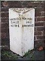
Old Milepost by the B5149, Bebington Road
Cast iron post by the B5149, in parish of BEBINGTON (WIRRAL District), Bebington Road; near Bebington Station, on path, back to wall, on East side of road. Cast iron CCC1901, erected by the County Council in the 20th century.
Inscription reads:-
: THORNTON HOUGH / 3½ MILES / NESTON 6 : : LOWER BEBINGTON / 1901 / URBAN COUNCIL : : NEW FERRY / ½ MILE / BIRKENHEAD 2¾ :
Maker:-
: W H SMITH & CO / MAKER / WHITCHURCH :
Milestone Society National ID: CH_BHNS03
Image: © C Smith
Taken: 1 Sep 2004
0.01 miles
2
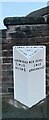
Old Milepost by the B5149, Bebington Road
Cast iron post by the B5149, in parish of BEBINGTON (WIRRAL District), Bebington Road; near Bebington Station, on path, back to wall, on East side of road. Cast iron CCC1901, erected by the County Council in the 20th century. An earlier photograph can be found here https://www.geograph.org.uk/photo/5362242.
Inscription reads:-
: THORNTON HOUGH / 3½ MILES / NESTON 6 : : LOWER BEBINGTON / 1901 / URBAN COUNCIL : : NEW FERRY / ½ MILE / BIRKENHEAD 2¾ :
Maker:-
: W H SMITH & CO / MAKER / WHITCHURCH :
Milestone Society National ID: CH_BHNS03
Image: © George William Lamb
Taken: 4 Sep 2022
0.01 miles
3
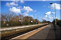
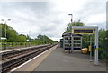
Bebington Station
A view looking towards Chester from the same location as Ben Brooksbank's historic photo http://geograph.org.uk/photo/1775236 nearly 49 years later.
The four roads of the Birkenhead Joint Railway's main line have been reduced to two for Merseyrail's Wirral line from Liverpool to Chester and Ellesmere Port. The site of the eastern platform and pair of tracks (beyond the green wire fence) is now devoted to car parking. The substantial brick buildings and platform awnings have been replaced by simple structures like bus shelters, and the chocolate and cream Western Region name signs have given way to slim contemporary ones.
Image: © Tiger
Taken: 7 Apr 2010
0.04 miles
4
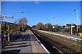
Bebington Station
Looking towards Liverpool on the Wirral Line of the Merseyrail system, formerly the main line of the Birkenhead Joint Railway.
Image: © Tiger
Taken: 7 Apr 2010
0.04 miles
5
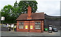
Sign at Bebington Station
Bebington is the nearest station for the Lady Lever Gallery, one of the Merseyside National Museums. This sign is on the up (Chester-bound) platform.
Image: © Tiger
Taken: 7 Apr 2010
0.04 miles
6
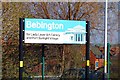
Bebington Railway Station
Opened in 1840. On the Chester and Ellesmere Port branches of the Wirral Line.
Entrance on the B5149.
Image: © JThomas
Taken: 15 Jun 2019
0.06 miles
7
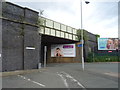
Railway bridge over Bebington Road (B5136)
Near Bebington Railway Station.
Image: © JThomas
Taken: 15 Jun 2019
0.07 miles
8
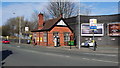
Bebington Station
Regular trains to and from Liverpool are operated by Mersey Rail.
Image: © Peter Mackenzie
Taken: 15 Mar 2017
0.07 miles
9
Greendale Road, Port Sunlight
Looking along a wide residential street in Port Sunlight village. To the left are houses, on the right is the embankment upon which the Mersey Rail line connecting Birkenhead and Chester runs.
Image: © Graham Robson
Taken: 12 Mar 2016
0.10 miles
10
Bebington Railway Station
Line towards Ellesmere Port and Chester.
Image: © JThomas
Taken: 15 Jun 2019
0.10 miles