IMAGES TAKEN NEAR TO
Oakridge Road, WIRRAL, CH62 2AS
Introduction
This page details the photographs taken nearby to Oakridge Road, CH62 2AS by members of the Geograph project.
The Geograph project started in 2005 with the aim of publishing, organising and preserving representative images for every square kilometre of Great Britain, Ireland and the Isle of Man.

There are currently over 7.5m images from over14,400 individuals and you can help contribute to the project by visiting https://www.geograph.org.uk
Image Map (Loading...)


Getting Data...Please wait
Leaflet Map data © OpenStreetMap
Images are licensed for reuse under creativecommons.org/licenses/by-sa/2.0
Notes
- Clicking on the map will re-center to the selected point.
- The higher the marker number, the further away the image location is from the centre of the postcode.
Image Listing (20 Images Found)
Images are licensed for reuse under creativecommons.org/licenses/by-sa/2.0
Image
Details
Distance
5
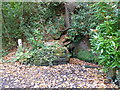
St Patricks Well in Brotherton Park
Image: © Raymond Knapman
Taken: 31 Oct 2014
0.16 miles
7
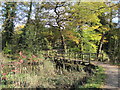
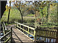
Footpath and footbridge over the River Dibbin
Image: © Sue Adair
Taken: 27 Oct 2012
0.17 miles
8
Footbridge over the River Dibbin in Brotherton Park
Image: © Raymond Knapman
Taken: 31 Oct 2014
0.17 miles
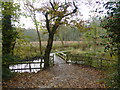
10
Babbs Meadow Footbridge
Footbridge over the River Dibbin linking Babbs Meadow with Otters Tunnel on the footpath around Brotherton Park and Dibbinsdale Local Nature Reserve.
Image: © Sue Adair
Taken: 27 Oct 2012
0.19 miles