IMAGES TAKEN NEAR TO
Pensby Road, WIRRAL, CH60 7RF
Introduction
This page details the photographs taken nearby to Pensby Road, CH60 7RF by members of the Geograph project.
The Geograph project started in 2005 with the aim of publishing, organising and preserving representative images for every square kilometre of Great Britain, Ireland and the Isle of Man.

There are currently over 7.5m images from over14,400 individuals and you can help contribute to the project by visiting https://www.geograph.org.uk
Image Map (Loading...)


Getting Data...Please wait
Leaflet Map data © OpenStreetMap
Images are licensed for reuse under creativecommons.org/licenses/by-sa/2.0
Notes
- Clicking on the map will re-center to the selected point.
- The higher the marker number, the further away the image location is from the centre of the postcode.
Image Listing (21 Images Found)
Images are licensed for reuse under creativecommons.org/licenses/by-sa/2.0
Image
Details
Distance
2
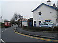
Heswall Gospel Hall
Heswall Gospel Hall, which stands high above Pensby Road, with a long flight of steps leading up to the imposing sliding doors, was built in 1924.
Image: © David Dixon
Taken: 6 Sep 2015
0.11 miles
3
Rose Cottage, Heswall
Rose Cottage on Sandy Lane, Heswall.
Image: © Sue Adair
Taken: 20 Mar 2007
0.13 miles
4
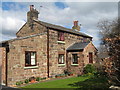
Plum Tree Cottage, Heswall
Plum Tree Cottage in Sandy Lane, Heswall built of the local red sandstone.
Image: © Sue Adair
Taken: 20 Mar 2007
0.13 miles
6
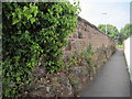
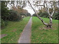
Footpath to Puddy Dale
Footpath cut through the sandstone from Pensby Road to Puddy Dale.
Image: © Sue Adair
Taken: 17 Sep 2014
0.17 miles
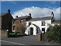
7
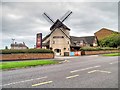
Harvest Mouse
Fayre and Square pub/restaurant in Heswall. The Harvest Mouse was purpose-built pub to a windmill design.
Image: © David Dixon
Taken: 6 Sep 2015
0.18 miles
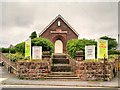
8
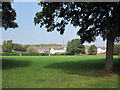
Puddy Dale
From 1909 to 1982 Heswall County Primary School occupied the eastern edge of this grassy area the centre of town which is known locally as 'Puddy Dale'.
Image: © Sue Adair
Taken: 17 Sep 2014
0.20 miles
9
Poll Hill
Drove to end of Tower Road South by the communication tower, pleasant area, then walked about a bit. This is the view SE from Tower Road South to Pole Hill Road.
Wirral current county/UA top.
Name: Poll Hill
Hill number: 5560
Height: 108m / 354ft
Area: 36: Lancashire, Cheshire & the Southern Pennines
Class: sHu,CoU
Grid ref: SJ 26749 82374
Summit feature: open ground by railing of communications compound
Drop: 97m
Col: 11m SJ415713
Image: © Rude Health
Taken: 18 Oct 2009
0.20 miles
10
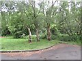
Poll Hill summit
Highest point on the Wirral. A patch of woodland deep in suburbia.
Image: © Richard Webb
Taken: 26 May 2022
0.22 miles