IMAGES TAKEN NEAR TO
Thurstaston Road, WIRRAL, CH60 4SA
Introduction
This page details the photographs taken nearby to Thurstaston Road, CH60 4SA by members of the Geograph project.
The Geograph project started in 2005 with the aim of publishing, organising and preserving representative images for every square kilometre of Great Britain, Ireland and the Isle of Man.

There are currently over 7.5m images from over14,400 individuals and you can help contribute to the project by visiting https://www.geograph.org.uk
Image Map
Images are licensed for reuse under creativecommons.org/licenses/by-sa/2.0
Notes
- Clicking on the map will re-center to the selected point.
- The higher the marker number, the further away the image location is from the centre of the postcode.
Image Listing (31 Images Found)
Images are licensed for reuse under creativecommons.org/licenses/by-sa/2.0
Image
Details
Distance
1
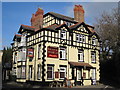
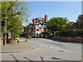
The Black Horse Inn
Situated in Lower Heswall, the attractive Black Horse Inn has gables and tall chimneys. Formerly the Heswall Hotel, the inn dates from 1843, the four storey building's lower two storeys being of white painted render with black quoins, the upper two have a mock timber frame. There are stables at the rear.
Image: © Sue Adair
Taken: 2 Feb 2014
0.04 miles
2
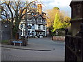
The Black Horse Hotel, Heswall Lower Village
The Black Horse and School Hill in Heswall Lower Village taken 13/03/2011
Image: © Tom Stapledon
Taken: 13 Mar 2011
0.06 miles
4
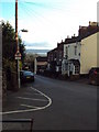
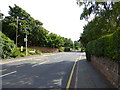
School Hill, Lower Heswall
View looking down School Hill with the Dee estuary beyond. Taken 13/3/2011
Image: © Tom Stapledon
Taken: 13 Mar 2011
0.08 miles
5
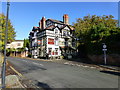
The Black Horse, Heswall
The Black Horse Hotel is situated in the pretty conservation area of lower Heswall opposite St Peters Church. It is a traditional pub, built in 1836 and formerly called the Heswall Hotel.
Image: © Eirian Evans
Taken: 17 May 2016
0.08 miles
6
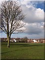
Thurstaston Road at junction with Herbert's Lane
Image: © Raymond Knapman
Taken: 28 Aug 2013
0.09 miles
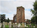
8
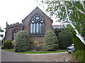
St Peter's Church, Heswall
Viewed from the east.
Image: © Eirian Evans
Taken: 17 May 2016
0.10 miles
9

School Hill
Stepped terrace of houses on the steep School Hill which formed the main access down to Heswall Lower Village from the through routes along the top of the ridge and passing the original school which was built in 1872.
Image: © Sue Adair
Taken: 2 Feb 2014
0.10 miles
10
St Peter's Parish Church
The oldest structure in Heswall is the base of the tower of St Peter's Parish Church, which dates back to 1306. The present church building itself, the third to have been erected on the site, was built in 1879. The previous church, built 1739, had been destroyed by a violent thunderstorm on 19thSeptember 1875.
Image: © Sue Adair
Taken: 16 Oct 2010
0.10 miles