IMAGES TAKEN NEAR TO
CH5 9WT
Introduction
This page details the photographs taken nearby to CH5 9WT by members of the Geograph project.
The Geograph project started in 2005 with the aim of publishing, organising and preserving representative images for every square kilometre of Great Britain, Ireland and the Isle of Man.

There are currently over 7.5m images from over14,400 individuals and you can help contribute to the project by visiting https://www.geograph.org.uk
Image Map
Images are licensed for reuse under creativecommons.org/licenses/by-sa/2.0
Notes
- Clicking on the map will re-center to the selected point.
- The higher the marker number, the further away the image location is from the centre of the postcode.
Image Listing (103 Images Found)
Images are licensed for reuse under creativecommons.org/licenses/by-sa/2.0
Image
Details
Distance
1
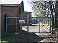
Queensferry Land Drainage Pumping Station
This pumping station is adjacent to the A494 just before it crosses the modern concrete bridge at Queensferry. The road is on the right, and is rising as it heads towards the river, behind the camera. The riverside footpath comes away from the river to this point, turns left to avoid the stream outflow, and then returns to the river bank.
Image: © John S Turner
Taken: 11 Apr 2007
0.08 miles
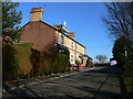
2
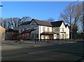
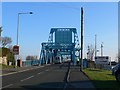
Hawarden Castle Hotel, Queensferry
A derelict hotel which has been closed for over a decade. It is just on the west side of the blue bascule bridge over the river Dee at Queensferry.
Image: © Eirian Evans
Taken: 1 Mar 2012
0.09 miles
3
Hawarden Castle Hotel, Queensferry
The Hawarden Castle Hotel is nowhere near Hawarden Castle, but it is a stylish name for a hostelry, which would have been busy in 1882 when it is shown on the O.S. map close to the Queen's Ferry (free). This was at a time before any bridges had been built over the River Dee downstream of Chester. The hotel is now closed and no one stops here any more. The road in front of the camera is the one that crosses the blue bascule bridge, which is just out of sight to the right, and the angled road across the front of the hotel is the road for the first bridge that pre-dated the blue one. That first bridge has been demolished.
Image: © John S Turner
Taken: 11 Apr 2007
0.10 miles
4
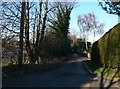
Wales Coast Path
Setting off on the section from Queensferry Bridge towards Flint.
Image: © Eirian Evans
Taken: 3 Feb 2012
0.10 miles
5
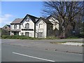
Bridge Villas, Queensferry
The bridge being the Queemsferry Bridge.
Image: © Eirian Evans
Taken: 3 Feb 2012
0.11 miles
6
Two Swans and the Queensferry Bridge
Looking downstream, towards the blue Queensferry bridge, from the corner of the riverside footpath where it goes under the modern concrete by-pass bridge. The pair of swans seem unconcerned about the traffic roaring past on either side.
Image: © John S Turner
Taken: 11 Apr 2007
0.11 miles
7
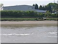
Abandoned Boat on the bank of the River Dee
Another wrecked and half buried boat lies abandoned on the banks of the River Dee. This one is at Queensferry located in the short stretch of river between the modern road bridge to the left, and the picturesque blue bascule bridge to the right. The large building behind the hedge is the Lindop Bros Toyota garage and workshop.
Image: © John S Turner
Taken: 20 Apr 2007
0.12 miles
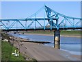
9
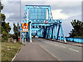
Blue Bridge (Jubilee Bridge), River Dee
Jubilee Bridge (Queensferry Bridge) is known locally as 'Blue Bridge'. It was constructed between 1925-7 (see http://news.webshots.com/photo/1136850593032811165qMWzzN and http://news.webshots.com/photo/1136850708032811165waLUpX for photos taken during its construction), replacing an earlier retracting bridge built in 1899.
The bridge was a major crossing point over the River Dee, linking Queensferry* and Garden City, before the neighbouring bridge carrying the A550 was built. This view is from Station Road.
According to Institute of Civil Engineers this is the only major bascule bridge in North Wales.(http://www.movablebridges.org.uk/BridgePage.asp?BridgeNumber=44 ).
*Queensferry got its name from a time when Queen Victoria used a ferry boat to cross the Dee from nearby Shotwick to Queensferry.
Image: © David Dixon
Taken: 23 May 2011
0.12 miles
10
Approaching the blue bridge from Queensferry
The bridge carries the B5441 over the Dee from Queensferry to Garden City. It does not carry as much traffic these days as there are now two more bridges crossing the Dee, one just south carrying the A494 and another further north carrying the A548
Image: © Eirian Evans
Taken: 1 Mar 2012
0.12 miles