IMAGES TAKEN NEAR TO
Green Lane West, DEESIDE, CH5 2LJ
Introduction
This page details the photographs taken nearby to Green Lane West, CH5 2LJ by members of the Geograph project.
The Geograph project started in 2005 with the aim of publishing, organising and preserving representative images for every square kilometre of Great Britain, Ireland and the Isle of Man.

There are currently over 7.5m images from over14,400 individuals and you can help contribute to the project by visiting https://www.geograph.org.uk
Image Map
Images are licensed for reuse under creativecommons.org/licenses/by-sa/2.0
Notes
- Clicking on the map will re-center to the selected point.
- The higher the marker number, the further away the image location is from the centre of the postcode.
Image Listing (13 Images Found)
Images are licensed for reuse under creativecommons.org/licenses/by-sa/2.0
Image
Details
Distance
1
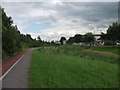
Cycle track and footpath
Footpath and cycle track from the Deeside Industrial Estate, which connects with Cycle Route 5. Image]
Image: © John Haynes
Taken: 18 Jun 2012
0.10 miles
2
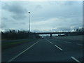
A550 looking west as A548 crosses on bridge
Image: © Colin Pyle
Taken: 4 Apr 2011
0.14 miles
3
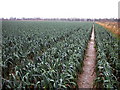
Leek field on the Welsh border
The Dee once flowed on this flat land just south of Shotwick village. In the 18th century the Dee was canalized and its course changed to the Welsh side of the estuary, but the border remains where the river once was. The border, viewed from the Welsh side, follows the far hedge.
Image: © John Hughes
Taken: 4 Jan 2008
0.15 miles
5
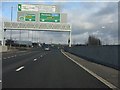
The route number changes - again
Passing the former RAF Sealand site, further chopping and changing and inconsistency in the signage for the through route between North Wales and the M56. Having changed from A494 to A550, we go back to A494 while the route off to Birkenhead takes the A550 number. The latter should not, technically, be shown in brackets on this sign, but that's a mere nit compared to the overall nonsense. For progressive signage from Ewloe, see: http://www.geograph.org.uk/photo/2252268 , http://www.geograph.org.uk/photo/2252285 & http://www.geograph.org.uk/photo/2252305.
Image: © Peter Whatley
Taken: 18 Jan 2011
0.15 miles
6
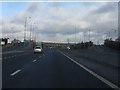
Junction panorama, A494/A548 intersection
A classic UK roundabout junction with two separate bridges.
Image: © Peter Whatley
Taken: 18 Jan 2011
0.15 miles
7
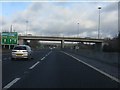
A494 - A548 junction bridges
More odd signage on this route visible on the left. Why is Manchester shown on the top line on one half of the sign, but Birkenhead (B'head) below the M53 symbol?
Image: © Peter Whatley
Taken: 18 Jan 2011
0.15 miles
8
Industrial estate drain
Like the agricultural land across the road the industrial estate is built on "sealand" and also has a pumped drainage system via the wild area in the middle of the estate. Image]
Image: © John Haynes
Taken: 18 Jun 2012
0.17 miles
9
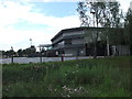
Office end of a large industrial unit
Modern hi-tech factory.
http://www.convatec.co.uk/
Image: © John Haynes
Taken: 18 Jun 2012
0.19 miles
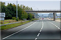
10
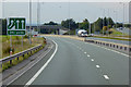
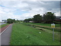
Westbound A494 approaching the Welsh Border
Image: © David Dixon
Taken: 24 Sep 2017
0.19 miles