IMAGES TAKEN NEAR TO
Kenneth Cross Way, DEESIDE, CH5 2FJ
Introduction
This page details the photographs taken nearby to Kenneth Cross Way, CH5 2FJ by members of the Geograph project.
The Geograph project started in 2005 with the aim of publishing, organising and preserving representative images for every square kilometre of Great Britain, Ireland and the Isle of Man.

There are currently over 7.5m images from over14,400 individuals and you can help contribute to the project by visiting https://www.geograph.org.uk
Image Map
Images are licensed for reuse under creativecommons.org/licenses/by-sa/2.0
Notes
- Clicking on the map will re-center to the selected point.
- The higher the marker number, the further away the image location is from the centre of the postcode.
Image Listing (9 Images Found)
Images are licensed for reuse under creativecommons.org/licenses/by-sa/2.0
Image
Details
Distance
1
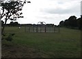
Grass Airfield
Viewed from the Garden City boundary of RAF Sealand, the grass airfield was mainly used by Air Cadet gliders until glider training was transferred to RAF Woodvale where No 631 Volunteer Gliding Squadron is now based.
Image: © Dennis Turner
Taken: 29 Apr 2009
0.12 miles
2
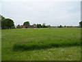
Play park and open space
Green space on the edge of Garden City.
Image: © John Haynes
Taken: 18 Jun 2012
0.19 miles
4
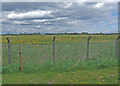
Airfield boundary
The fence marks the boundary of the MOD grass airfield with the road in the foreground leading to the grandly named Garden City Industrial Estate.
Image: © Dennis Turner
Taken: 29 Apr 2009
0.21 miles
5
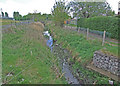
Drainage ditch
Drainage of the low lying land, most of which has been reclaimed from the river, is very important in the area.
Image: © Dennis Turner
Taken: 29 Apr 2009
0.21 miles
6
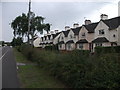
Roadside houses
What I believe to be the old "pad" houses at RAF Sealand.
Image: © John Haynes
Taken: 18 Jun 2012
0.22 miles
7
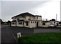
The Leprechaun pub
Pub with TV and a weekend carvery, used to be a roadhouse but now only a local pub as the main road rushes by behind the concrete wall. Image]
Image: © John Haynes
Taken: 18 Jun 2012
0.23 miles
8
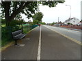
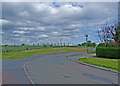
Dual use path beside Welsh Road (B5441)
Looking north east.
Image: © JThomas
Taken: 25 May 2019
0.23 miles
