IMAGES TAKEN NEAR TO
By-Pass Road, DEESIDE, CH5 2DU
Introduction
This page details the photographs taken nearby to By-Pass Road, CH5 2DU by members of the Geograph project.
The Geograph project started in 2005 with the aim of publishing, organising and preserving representative images for every square kilometre of Great Britain, Ireland and the Isle of Man.

There are currently over 7.5m images from over14,400 individuals and you can help contribute to the project by visiting https://www.geograph.org.uk
Image Map
Images are licensed for reuse under creativecommons.org/licenses/by-sa/2.0
Notes
- Clicking on the map will re-center to the selected point.
- The higher the marker number, the further away the image location is from the centre of the postcode.
Image Listing (84 Images Found)
Images are licensed for reuse under creativecommons.org/licenses/by-sa/2.0
Image
Details
Distance
1
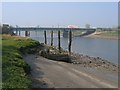
Ruined Jetty by the River Dee
On the 1882 O.S. map landing stages were recorded all along this part of the river, however this one seems to be later as it is in a slightly different position. In 1882 neither of the Queensferry bridges existed, so there was ferry traffic across the river as well commercial traffic along it. The relatively modern concrete bridge can be seen behind the jetty, and beyond that the top of the old blue bridge can be seen.
Image: © John S Turner
Taken: 27 Mar 2007
0.06 miles
2
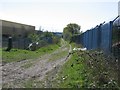
Track by the River Dee
According to the 1882 O.S. map this track and footpath was once a rail line, which ran from a colliery at 'Big Mancot' out to a jetty on the edge of the River Dee. Presumably the line carried coal from the colliery out to vessels waiting in the river.
Image: © John S Turner
Taken: 11 Apr 2007
0.07 miles
3
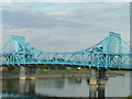
Queensferry river bridge
This is a steel construction 'Bascule' type road bridge, constructed to replace a previous wooden bridge - not sure of the construction date
Image: © alan smethurst
Taken: 14 Jul 2005
0.08 miles
4
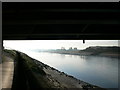
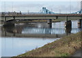
The river Dee
Looking southward down the river from under the A494 road bridge.
Image: © Eirian Evans
Taken: 1 Mar 2012
0.08 miles
5
The two Queensferry bridges and a swan
A hastily taken photo of the two bridges, from the River Dee Coastal Path, to try and catch the swan flying beneath the modern bridge - far left of picture.
Image: © John S Turner
Taken: 24 Jan 2009
0.09 miles
6
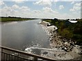
River Dee at Queensferry
Looking upstream at the Southern bank of the River Dee at Queensferry.
Image: © Gerald England
Taken: 4 Jul 2008
0.09 miles
7
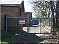
Queensferry Land Drainage Pumping Station
This pumping station is adjacent to the A494 just before it crosses the modern concrete bridge at Queensferry. The road is on the right, and is rising as it heads towards the river, behind the camera. The riverside footpath comes away from the river to this point, turns left to avoid the stream outflow, and then returns to the river bank.
Image: © John S Turner
Taken: 11 Apr 2007
0.09 miles
8
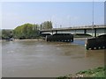
The Modern Queensferry Road Bridge
This view of the modern Queensferry road bridge is from the cycleway between Chester and Queensferry. The tidal bore has just passed and the tide is running strongly upstream to the left against the river flow.
Image: © John S Turner
Taken: 20 Apr 2007
0.11 miles
9
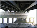
Under the Queensferry Bridge
Underneath the modern Queensferry bridge, which carries a huge amount of traffic to and from North Wales. The River Dee is particularly low in this photo.
Image: © John S Turner
Taken: 27 Mar 2007
0.11 miles
10
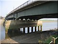
The Modern Queensferry Bridge
A view of the modern Queensferry Bridge from the Riverside footpath. It is constructed from steel girders and a concrete base, with concrete piles sunk into the river bed. Subject to all the necessary approvals, it is intended to build another bridge alongside to increase capacity.
Image: © John S Turner
Taken: 27 Mar 2007
0.11 miles