IMAGES TAKEN NEAR TO
Common Lane, CHESTER, CH4 9LG
Introduction
This page details the photographs taken nearby to Common Lane, CH4 9LG by members of the Geograph project.
The Geograph project started in 2005 with the aim of publishing, organising and preserving representative images for every square kilometre of Great Britain, Ireland and the Isle of Man.

There are currently over 7.5m images from over14,400 individuals and you can help contribute to the project by visiting https://www.geograph.org.uk
Image Map
Images are licensed for reuse under creativecommons.org/licenses/by-sa/2.0
Notes
- Clicking on the map will re-center to the selected point.
- The higher the marker number, the further away the image location is from the centre of the postcode.
Image Listing (13 Images Found)
Images are licensed for reuse under creativecommons.org/licenses/by-sa/2.0
Image
Details
Distance
2
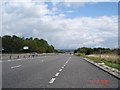
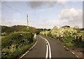
A55 near Balderton
The A55 dual carriageway (taken from layby) looking back towards the footbridge over the carriageway
Image: © Dot Potter
Taken: 14 Aug 2005
0.13 miles
3
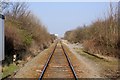
The Shrewsbury-Chester Railway Line at Balderton
The Shrewsbury-Chester railway line at Balderton level crossing heading north towards Chester. The bridge in the distance carries the A55.
Image: © Jeff Buck
Taken: 5 Mar 2013
0.14 miles
4
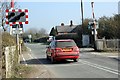
Balderton Level Crossing
Balderton level crossing on Lache Lane approaching Roughhill.
Image: © Jeff Buck
Taken: 5 Mar 2013
0.14 miles

6
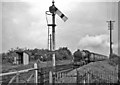
Site of Balderton Station
View NE, towards Chester; ex-GWR Shrewsbury - Chester main line. This station had been closed on 3/3/52. It remained open for goods until 1/11/64, although this is not apparent from the photograph, which shows a typical GWR Up express (headed by a 'County' class 4-6-0) and GWR lower-quadrant signal.
Image: © Ben Brooksbank
Taken: 21 May 1961
0.15 miles
7
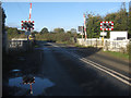
Balderton Crossing on Lache Lane
Looking west across Balderton barrier-controlled crossing. Previously a gated level crossing this site also had a signal box, and a station that was closed in 1952. See also Image
Image: © John S Turner
Taken: 21 Oct 2010
0.15 miles

9
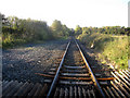
Railway line at Balderton Crossing
Looking south, in the direction of Shrewsbury, from Balderton Crossing. The width of the track bed indicates that this was once a double track main line, as can be seen in Image; there was also a station on the other side of the lane. On the right of the photo there used to be a signal box. The stone bridge in the distance carries Balderton Drive that once was an approach road to Eaton Hall for the Duke of Westminster. The A55 has now severed that link.
Image: © John S Turner
Taken: 21 Oct 2010
0.15 miles
10
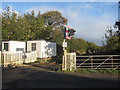
Site of Balderton Station 2010
A repeat of Ben Brooksbank's 1961 photo, Image but without the train and with more tree and bush growth. The workmen's shelter has improved greatly as well. Balderton crossing is now barrier controlled - Image
Image: © John S Turner
Taken: 21 Oct 2010
0.15 miles