IMAGES TAKEN NEAR TO
Cortsway, WIRRAL, CH49 2NA
Introduction
This page details the photographs taken nearby to Cortsway, CH49 2NA by members of the Geograph project.
The Geograph project started in 2005 with the aim of publishing, organising and preserving representative images for every square kilometre of Great Britain, Ireland and the Isle of Man.

There are currently over 7.5m images from over14,400 individuals and you can help contribute to the project by visiting https://www.geograph.org.uk
Image Map (Loading...)


Getting Data...Please wait
Leaflet Map data © OpenStreetMap
Images are licensed for reuse under creativecommons.org/licenses/by-sa/2.0
Notes
- Clicking on the map will re-center to the selected point.
- The higher the marker number, the further away the image location is from the centre of the postcode.
Image Listing (10 Images Found)
Images are licensed for reuse under creativecommons.org/licenses/by-sa/2.0
Image
Details
Distance
1
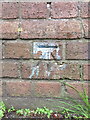
Bench mark on Upton Bridge, Greasby Road, Wirral
This Ordnance Survey bench mark is on the south parapet of Upton Bridge, which carries Greasby Road over Arrowe Brook. See also Image
Image: © John S Turner
Taken: 25 May 2018
0.19 miles
2
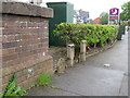
Upton Bridge parapet in Greasby Road, Wirral
The parapet of Upton Bridge, which carries Greasby Road over Arrowe Brook next to the Premier Inn. There is an Ordnance Survey bench mark on the parapet - Image, and some water company markers beyond, including an old and weathered 'WCWB SV' post - 'Wirral Corporation(?) Water Board Stop Valve' - Image
Image: © John S Turner
Taken: 25 May 2018
0.19 miles
3
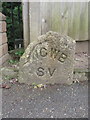
An old Wirral Corporation(?) Water Board Stop Valve marker
This old 'Wirral Corporation(?) Water Board Stop Valve' marker is alongside Upton Bridge in Greasby Road, Wirral. Newer markers stand next to it - Image
Image: © John S Turner
Taken: 25 May 2018
0.19 miles
4
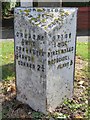
Old Milepost by the B5139, Hoylake
Cast iron post by the B5139, in parish of HOYLAKE (WIRRAL District), East of Brookdale Ave junction, on the verge, on South East side of road. Cast iron CCC 1898, erected by Cheshire County Council in the 19th century.
Inscription reads:-
: GREASBY / ⅔ MILE / FRANKBY 1⅓ / GRANGE / CORNER 2¾ : : CHESHIRE / 1898 / COUNTY COUNCIL : : UPTON / ½ MILE / BIRKENHEAD / WOODSIDE / FERRY 5 :
Maker:-
: W H SMITH & CO / MAKER / WHITCHURCH :
Milestone Society National ID: CH_BHGC05.
Image: © Milestone Society
Taken: Unknown
0.20 miles
5
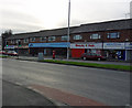
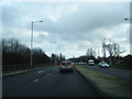
Retail Therapy
Retail outlets at Saughall Massie Road, Saughall Massie.
Image: © J Scott
Taken: 14 Nov 2010
0.20 miles
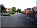
10
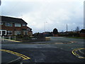
Saughall Massie Road/Brookside Crescent junction
Image: © Colin Pyle
Taken: 27 Jan 2012
0.25 miles