IMAGES TAKEN NEAR TO
Victoria Road, CHESTER, CH4 8SY
Introduction
This page details the photographs taken nearby to Victoria Road, CH4 8SY by members of the Geograph project.
The Geograph project started in 2005 with the aim of publishing, organising and preserving representative images for every square kilometre of Great Britain, Ireland and the Isle of Man.

There are currently over 7.5m images from over14,400 individuals and you can help contribute to the project by visiting https://www.geograph.org.uk
Image Map
Images are licensed for reuse under creativecommons.org/licenses/by-sa/2.0
Notes
- Clicking on the map will re-center to the selected point.
- The higher the marker number, the further away the image location is from the centre of the postcode.
Image Listing (18 Images Found)
Images are licensed for reuse under creativecommons.org/licenses/by-sa/2.0
Image
Details
Distance
1
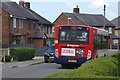
Victoria Road, Saltney
Although most of Saltney is across the Welsh border in Flintshire, it is to all intents and purposes a Chester suburb. Here a Stagecoach bus on route 16 threads its way around the housing estate before returning to Chester bus station. The poster on the rear is advertising an open day at Wrexham Glyndŵr University.
Image: © Stephen McKay
Taken: 14 Jun 2018
0.09 miles
2
Victoria Road, Saltney
Seen from the junction with Boundary Lane. This is actually in Wales, albeit only just, but the locals are evidently supporting England in the World Cup which was due to start in Russia later the same day.
Image: © Stephen McKay
Taken: 14 Jun 2018
0.10 miles
3
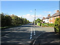
Boundary Lane, Saltney
Taken at the junction with Kinnerton Close. As the name suggests, Boundary Lane runs along the English/Welsh border.
Wikipedia http://en.wikipedia.org/wiki/Saltney
Image: © Jeff Buck
Taken: 10 Oct 2013
0.11 miles
4
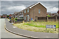
Tegid Way, Saltney
Suburban housing seen from the junction with Sandy Lane.
Image: © Stephen McKay
Taken: 14 Jun 2018
0.12 miles
5
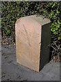
Modern Boundary Marker by Boundary Lane, Saltney, Chester Parish
Parish Boundary Marker by the UC road, in parish of Chester (Chester District), Boundary Lane Saltney, in front of No 118. Adjacent to MSSid: CH_CHES03pb Image
Inscription reads:- : CHESTER / 1998 :
Surveyed
Milestone Society National ID: CH_CHES01pb
Image: © John S Turner
Taken: 7 Apr 2009
0.12 miles
6
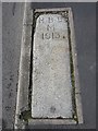
Old Boundary Marker by Boundary Lane, Saltney, Chester Parish
Parish Boundary Marker by the UC road, in parish of Chester (Chester District), Boundary Lane, Saltney, in front of No 118 laid in pavement. Apparently relocated from the vulnerable corner opposite. Adjacent to MSSid: CH_CHES01pb Image
Inscription reads:-
H B D
M
1913
(Harry B. Dutton, Mayor of Chester 1912/3)
To be surveyed
Milestone Society National ID: CH_CHES03pb
Image: © John S Turner
Taken: 7 Apr 2009
0.13 miles
7
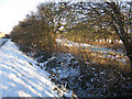
The site of Holy Epiphany church
In between the roadside hedge and the angled hedge on the right is a triangular plot that was once the site of the Holy Epiphany church, parish of Lache cum Saltney. The church was consecrated on the 9th January 1855, and the plot is in Cheshire, with the national boundary with Wales running through the camera position. At that time the location of the church was some distance from the centre of population and so in 1893 the church of St. Mark was consecrated on the corner of St Mark's Road and Hough Green. Holy Epiphany is not recorded on the 1899 O.S. map so presumably it had been demolished by then. Today the plot is just a field grazed by sheep. For more information see: http://www.genuki.org.uk/big/wal/FLN/Saltney/index.html
Image: © John S Turner
Taken: 24 Dec 2010
0.13 miles
8
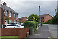
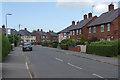
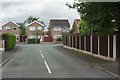
Boundary Lane, Saltney
At first glance, this might be dismissed as a wholly unremarkable slice of suburbia but the road has the distinction of running along the border between England and Wales, so the houses on the left are in Flintshire and those on the right are within the Cheshire West and Chester unitary authority area. There is nothing here to indicate this situation, although the name of the street gives a clue.
Image: © Stephen McKay
Taken: 14 Jun 2018
0.13 miles
9
Padarn Close, Saltney
Padarn Close is a cul-de-sac leading off Sandy Lane. Although this part of Saltney lies just over the Welsh border in Flintshire, it is to all intents and purposes a suburb of Chester.
Image: © Stephen McKay
Taken: 14 Jun 2018
0.13 miles
10
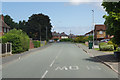
Boundary Lane, Saltney
The border between England and Wales runs along this road so that the houses on the left are in Flintshire and those on the right are in the West Cheshire and Chester unitary authority area.
Image: © Stephen McKay
Taken: 14 Jun 2018
0.13 miles