1
Heather Brow, Heather Brow, Birkenhead
Image: © Alex McGregor
Taken: 20 Oct 2011
0.06 miles
2
Upton Road in Claughton Birkenhead
Liverpool C of E Cathedral in background
Image: © Raymond Knapman
Taken: 30 Aug 2012
0.10 miles
3
Birkenhead Transport bus 252 on Tollemache Road ? 1967
The driver would have his foot hard on the floor to tackle the steep section of Tollemache Road ahead (approx 1 in 10). This was my local bus service and usually the bus would have slowed down enough on the gradient to enable one to drop off at the end of my road rather than being carried another 100 yards or so to the official stop.
Behind the bus can be seen the rear of St Aidans Terrace, a fine classical terrace from a relatively early period of the development of the town (c.1850), Listed Grade II.
The bus is one of the wartime (1944) Guy Arab II buses which were given new Massey bodies in 1953 and would remain in service until 1969 after 25 years' service.
This is one of a series of views featuring buses in the 60s, 70s, and 80s.
http://www.geograph.org.uk/search.php?i=2114547&displayclass=slide
Image: © Alan Murray-Rust
Taken: 18 Feb 1967
0.12 miles
4
Claughton Village
The main row of shops along the main road of Claughton Village.
Image: © David Quinn
Taken: 21 Jun 2006
0.15 miles
5
Mona Street, Birkenhead
Image: © Alex McGregor
Taken: 20 Oct 2011
0.15 miles
6
Castellated gatehouse at Birkenhead Park
Castellated gatehouse at Birkenhead Park. Opened in 1847, the park is the world's first public park. It was designed by Sir Joseph Paxton who also designed the Crystal Palace at the Great Exhibition and influenced the design of many parks around the world including Central Park, New York.
Image: © Sue Adair
Taken: 13 Nov 2005
0.16 miles
7
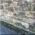
A damaged benchmark
At this coordinate, there is supposed to be an OS benchmark, but it has been logged as destroyed. The logger makes the note "Wall shows signs of repair, and there is no trace of this mark." https://www.bench-marks.org.uk/bm106864. However, on closer inspection, one can make out the line and arrow on the pale stone diagonally up from the seedling in the lower right corner of the photo. The benchmark was originally 0.5 m above ground level. I suspect that the wall was partly demolished when it was repaired, and this stone found itself in a different position in the wall.
Image: © Neville Goodman
Taken: 1 Apr 2022
0.16 miles
8
Stone plaque marking the site of St Aidan's College
St Aidan's Theological College was a large brick building built in the Tudor style, which taught Anglican students of theology. It is now demolished, and replaced by housing on the site. This plaque in one of the original walls surrounding the site is located approximately 100 metres north of the original building.
Image: © Robin Lucas
Taken: 28 Jan 2011
0.17 miles
9
Castellated Lodge, Park Road West, Birkenhead
A single lodge at the west end of Birkenhead Park. By John Robertson and Lewis Hornblower, c1845. Grade II listed.
Image: © Stephen Richards
Taken: 22 Aug 2014
0.19 miles
10
Roundabout at Egerton Road
A Birkenhead Corporation bus on the anticlockwise North Circle route 94 negotiates the hourglass shaped roundabout at the junction Egerton Road and Tollemache Road (rear left). Until just a few years previously this had been simply a wide open space of road which in the other direction could be swept through at speed to take a run at the ensuing gradient on Tollemache Road.
Birkenhead Corporation would lose control of its buses in a couple of years' time with the formation of the Merseyside PTE.
This is one of a series of views featuring buses in the 60s, 70s, and 80s. http://www.geograph.org.uk/search.php?i=2114547&displayclass=slide
Image: © Alan Murray-Rust
Taken: 7 Mar 1970
0.20 miles


