IMAGES TAKEN NEAR TO
Holm Cottages, PRENTON, CH43 2HL
Introduction
This page details the photographs taken nearby to Holm Cottages, CH43 2HL by members of the Geograph project.
The Geograph project started in 2005 with the aim of publishing, organising and preserving representative images for every square kilometre of Great Britain, Ireland and the Isle of Man.

There are currently over 7.5m images from over14,400 individuals and you can help contribute to the project by visiting https://www.geograph.org.uk
Image Map
Images are licensed for reuse under creativecommons.org/licenses/by-sa/2.0
Notes
- Clicking on the map will re-center to the selected point.
- The higher the marker number, the further away the image location is from the centre of the postcode.
Image Listing (5 Images Found)
Images are licensed for reuse under creativecommons.org/licenses/by-sa/2.0
Image
Details
Distance
2
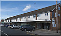
Shopping parade and medical centre, Holmlands Drive
Image: © Ian Greig
Taken: 14 Jul 2017
0.17 miles
3
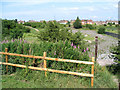
Reclamation Project Prenton
I was out Geographing and came across this, which I knew nothing about. The right hand portion looks like a water feature on the photo, but it's actually shrubs recently planted in gravelly soil. There is also a totem pole in the foreground - it's not a drainpipe! On the right hand side, out of sight, is a large electricity transformer station.
Image: © Peter Craine
Taken: 6 Jul 2006
0.24 miles
4
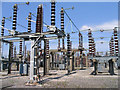
Electricity Station, Prenton
There is a large electricity station on the border of this gridsquare. It is rather ironic that they use an electric fence to keep out intruders!
Image: © Peter Craine
Taken: 6 Jul 2006
0.24 miles
5
Woodchurch Road Prenton
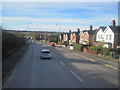
Woodchurch Road Prenton looking down into the Fender valley which now houses junction 3 of the M53 motorway and the Borderlands (Wrexham to Bidston) railway. The line opened in 1896, as the North Wales & Liverpool Railway alongside the river which flows north to join the Birket at Leasowe. In the distance can be seen the fields of the ancient hamlet of Landican and to the right Arrowe Park Hospital.
Image: © Sue Adair
Taken: 21 Nov 2015
0.24 miles