IMAGES TAKEN NEAR TO
Rock Park, BIRKENHEAD, CH42 1PL
Introduction
This page details the photographs taken nearby to Rock Park, CH42 1PL by members of the Geograph project.
The Geograph project started in 2005 with the aim of publishing, organising and preserving representative images for every square kilometre of Great Britain, Ireland and the Isle of Man.

There are currently over 7.5m images from over14,400 individuals and you can help contribute to the project by visiting https://www.geograph.org.uk
Image Map
Images are licensed for reuse under creativecommons.org/licenses/by-sa/2.0
Notes
- Clicking on the map will re-center to the selected point.
- The higher the marker number, the further away the image location is from the centre of the postcode.
Image Listing (49 Images Found)
Images are licensed for reuse under creativecommons.org/licenses/by-sa/2.0
Image
Details
Distance
1
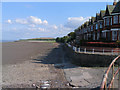
Esplanade, New Ferry, Wirral
This was taken at low tide as evidenced by the trolley in the foreground. The mound in the distance is reclaimed land which is now being used as a rubbish tip. Despite all this, it is a great place to visit and the views are excellent.
Image: © Peter Craine
Taken: 6 Jul 2006
0.03 miles
2
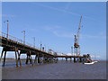
Pier at New Ferry, Wirral
I think they'll take this pier down soon, for safety reasons. I don't think it's used anymore. The background is Liverpool (Garden Festival site).
Image: © Peter Craine
Taken: 10 Apr 2005
0.03 miles
4

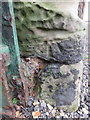
Pivot benchmark by #9 Rock Park Road, Birkenhead
Pivot benchmark on the low boundary wall to #9 Rock Park Road. The mark is a genuine Ordnance Survey mark, which is recorded on the O.S. legacy s/sheet, but I can't find it on any maps I've seen. It is at the top of a curved footpath down to Esplanade, and there is another benchmark at the bottom of the path, which does seem to make sense. The curved path is now overgrown and full of rubbish behind a locked gate at the Esplanade. For a wider view see Image
Benchmark Database: https://www.bench-marks.org.uk/bm218174
Image: © John S Turner
Taken: 21 Mar 2016
0.06 miles
5
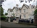
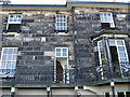
12-13 Rock Park, Birkenhead
Two of the comfortable riverside villas built by the Royal Rock Ferry Company in the 1840s, laid out by Jonathan Bennison. Much of the estate, including a hotel, lodges and gates, went when a dual carriageway was put through in the early 1970s. Grade II listed.
Image: © Stephen Richards
Taken: 21 Aug 2014
0.07 miles
6
Weathered bench mark on Esplanade, Rock Ferry
This badly weathered bench mark is at the bottom of a curved, gated footpath that links Esplanade with Rock Park Road. See also Image
Image: © John S Turner
Taken: 21 Mar 2016
0.09 miles
7
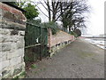
Gated footpath on Esplanade, Rock Ferry
The gated footpath on the left links Esplanade with Rock Park Road above, however, the gate is locked and there is a pile of rubbish of all sorts behind the gate. There is an Ordnance Survey bench mark on the sandstone wall below the modern brickwork - Image
Image: © John S Turner
Taken: 21 Mar 2016
0.09 miles
9
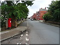
Rock Lane East
Showing position of Postbox No. CH42 3.
See Image] for postbox.
Image: © JThomas
Taken: 15 Jun 2019
0.10 miles
10
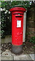
George V postbox on Rock Lane East
Postbox No. CH42 3.
See Image] for context.
Image: © JThomas
Taken: 15 Jun 2019
0.10 miles