IMAGES TAKEN NEAR TO
Milton Road, BIRKENHEAD, CH42 0JU
Introduction
This page details the photographs taken nearby to Milton Road, CH42 0JU by members of the Geograph project.
The Geograph project started in 2005 with the aim of publishing, organising and preserving representative images for every square kilometre of Great Britain, Ireland and the Isle of Man.

There are currently over 7.5m images from over14,400 individuals and you can help contribute to the project by visiting https://www.geograph.org.uk
Image Map
Images are licensed for reuse under creativecommons.org/licenses/by-sa/2.0
Notes
- Clicking on the map will re-center to the selected point.
- The higher the marker number, the further away the image location is from the centre of the postcode.
Image Listing (15 Images Found)
Images are licensed for reuse under creativecommons.org/licenses/by-sa/2.0
Image
Details
Distance
3
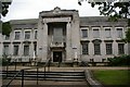
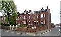
Wirral Christian Centre
This was converted from a children's hospital to a religious centre in the seventies. It also provides services such as residential home, nursery and luncheon club. Located on Woodchurch Road in Birkenhead.
Image: © Peter Craine
Taken: 19 Jul 2006
0.20 miles
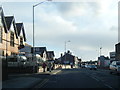
4
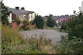
Car park next to Balls Road East
Subject to a planning application to redevelop the area, see http://www.wirral.gov.uk/planning/plansthumbs.asp?appnum=20066824&wanted=Plans
Image: © Peter Craine
Taken: 30 Sep 2007
0.21 miles
5
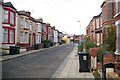
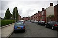
Belmont, Birkenhead
This road is called simply 'Belmont'. As you can see, several houses are boarded up. It appears to be subject to a planning application to redevelop the area. Suggested maps and diagrams can be viewed at http://www.wirral.gov.uk/planning/plansthumbs.asp?appnum=20066824&wanted=Plans
Image: © Peter Craine
Taken: 30 Sep 2007
0.21 miles
7
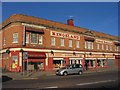
Kingsland Cabaret Restaurant, Birkenhead
According to Wikipedia, the main entrance to the restaurant is actually a grand fireplace removed from an old building, also called 'Kingsland'.
On the ground floor, there is a furniture shop called 'Suite Sensation'.
Image: © Peter Craine
Taken: 3 Nov 2006
0.23 miles
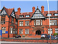
8
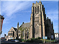
Oxton Congregational Church
This imposing gothic-styled church is a grade II listed building at 'the gateway' to Oxton. Having been derelict for many years, it has now been restored by the Wirral Christian Centre. It's great that at least one noteworthy building is being saved in this area.
Image: © Peter Craine
Taken: 28 Jul 2006
0.23 miles
10
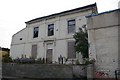
House on Belmont
'Belmont' being the name of the road. This was once a nice house, and it would be a shame to see it go. However, there is a planning application to redevelop the area, see http://www.wirral.gov.uk/planning/RegisterEntry.asp?appnum=20067471&wanted=Register
Image: © Peter Craine
Taken: 30 Sep 2007
0.23 miles