IMAGES TAKEN NEAR TO
Vittoria Street, BIRKENHEAD, CH41 3NT
Introduction
This page details the photographs taken nearby to Vittoria Street, CH41 3NT by members of the Geograph project.
The Geograph project started in 2005 with the aim of publishing, organising and preserving representative images for every square kilometre of Great Britain, Ireland and the Isle of Man.

There are currently over 7.5m images from over14,400 individuals and you can help contribute to the project by visiting https://www.geograph.org.uk
Image Map
Images are licensed for reuse under creativecommons.org/licenses/by-sa/2.0
Notes
- Clicking on the map will re-center to the selected point.
- The higher the marker number, the further away the image location is from the centre of the postcode.
Image Listing (37 Images Found)
Images are licensed for reuse under creativecommons.org/licenses/by-sa/2.0
Image
Details
Distance
1
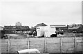
Birkenhead Corporation works yard, Corporation Street ? 1966
The two white painted buses are former corporation buses converted to mobile toilets which could be taken to various events as required. This was before the age of the portable prefabricated loo.
This is still the main services depot for Wirral Council.
Image: © Alan Murray-Rust
Taken: 22 Oct 1966
0.04 miles
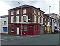
2
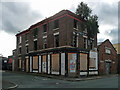
Former pub, Neptune Street, Birkenhead
A foot-soldier in the army of derelict Merseyside pubs. Judging by the greenery, the Mersey Arms has been closed for a while.
Five years before this photo it looked like this Image Somebody, or something, has nabbed the sign, and given the bush on the left a trim.
Image: © Stephen Richards
Taken: 21 Aug 2014
0.06 miles
4
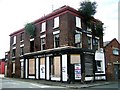
Derelict Pub, Neptune Street, Birkenhead
This derelict wreck, that was the former Mersey Arms Public House, is situated on the corner of Neptune Street & Corporation Road. Now home to the hanging gardens of Birkenhead.
Image: © El Pollock
Taken: 18 Jul 2009
0.07 miles
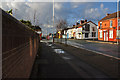
6

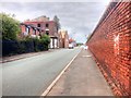
Vittoria Street/Cleveland Street junction
Image: © Colin Pyle
Taken: 14 Sep 2012
0.09 miles
7
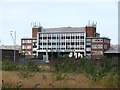
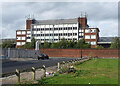
South Atlantic Building, Vittoria Dock, Birkenhead
W.H. Boase & Company Ltd. wharfingers office for the Blue Funnel line. Built circa. 1960. The offices were only used for about ten years. Either side of the office are the Vittoria Dock warehouses. As viewed from Cleveland Street.
Image: © El Pollock
Taken: 8 Aug 2009
0.09 miles
8
2-4 Pool Street, Birkenhead
This was once a pub, the Wheatsheaf.
It appears to have been turned into a private house, in an otherwise non-residential area.
Image: © Stephen Richards
Taken: 21 Aug 2014
0.13 miles
9
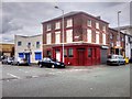
Birkenhead, Pool Street
The building on the corner looks like it might have been a pub at one time. The adjoining building (with the blue shutters) carries the name "Peerless Brewing Company" (an independent microbrewery https://en.wikipedia.org/wiki/Peerless_Brewing_Company )
Image: © David Dixon
Taken: 30 Jul 2015
0.13 miles
10
South Atlantic Building, Corporation Road, Birkenhead
Built as offices of the Blue Funnel Line, c1960. Vittoria Dock lies on the other side and its warehouses stretch along its length either side of this building, now disused.
Image: © Stephen Richards
Taken: 21 Aug 2014
0.14 miles