IMAGES TAKEN NEAR TO
Oxton Road, BIRKENHEAD, CH41 2TW
Introduction
This page details the photographs taken nearby to Oxton Road, CH41 2TW by members of the Geograph project.
The Geograph project started in 2005 with the aim of publishing, organising and preserving representative images for every square kilometre of Great Britain, Ireland and the Isle of Man.

There are currently over 7.5m images from over14,400 individuals and you can help contribute to the project by visiting https://www.geograph.org.uk
Image Map
Images are licensed for reuse under creativecommons.org/licenses/by-sa/2.0
Notes
- Clicking on the map will re-center to the selected point.
- The higher the marker number, the further away the image location is from the centre of the postcode.
Image Listing (32 Images Found)
Images are licensed for reuse under creativecommons.org/licenses/by-sa/2.0
Image
Details
Distance
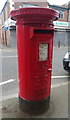
1
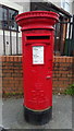
Elizabeth II postbox on Oxton Road, Birkenhead
Postbox No. CH41 163.
Image: © JThomas
Taken: 25 May 2019
0.02 miles
2
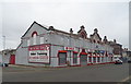
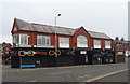
Motorcycle shop on Whetstone Lane, Birkenhead
Image: © JThomas
Taken: 25 May 2019
0.02 miles
3
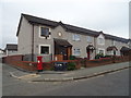
Houses on Oxton Road, Birkenhead
Showing position of Postbox No. CH41 163.
Image: © JThomas
Taken: 25 May 2019
0.02 miles
4
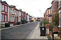
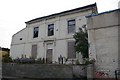
Belmont, Birkenhead
This road is called simply 'Belmont'. As you can see, several houses are boarded up. It appears to be subject to a planning application to redevelop the area. Suggested maps and diagrams can be viewed at http://www.wirral.gov.uk/planning/plansthumbs.asp?appnum=20066824&wanted=Plans
Image: © Peter Craine
Taken: 30 Sep 2007
0.08 miles
5
House on Belmont
'Belmont' being the name of the road. This was once a nice house, and it would be a shame to see it go. However, there is a planning application to redevelop the area, see http://www.wirral.gov.uk/planning/RegisterEntry.asp?appnum=20067471&wanted=Register
Image: © Peter Craine
Taken: 30 Sep 2007
0.08 miles
6
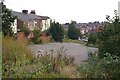
Car park next to Balls Road East
Subject to a planning application to redevelop the area, see http://www.wirral.gov.uk/planning/plansthumbs.asp?appnum=20066824&wanted=Plans
Image: © Peter Craine
Taken: 30 Sep 2007
0.10 miles
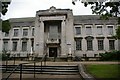
8
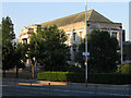
Birkenhead Central Library
This was opened in 1934 by King George V. The road in the foreground is Borough Road, one of the main ones in Birkenhead. This particular area used to be known as "Happy Valley" - I'm not sure why... but there was a pub of the same name nearby. Borough Road, incidentally, used to be a river.
Image: © Peter Craine
Taken: 19 Jul 2006
0.11 miles
10
Elizabeth II postbox on Oxton Road, Birkenhead
Postbox No. CH41 460.
Image: © JThomas
Taken: 25 May 2019
0.12 miles