IMAGES TAKEN NEAR TO
Tower Wharf, BIRKENHEAD, CH41 1LH
Introduction
This page details the photographs taken nearby to Tower Wharf, CH41 1LH by members of the Geograph project.
The Geograph project started in 2005 with the aim of publishing, organising and preserving representative images for every square kilometre of Great Britain, Ireland and the Isle of Man.

There are currently over 7.5m images from over14,400 individuals and you can help contribute to the project by visiting https://www.geograph.org.uk
Image Map
Images are licensed for reuse under creativecommons.org/licenses/by-sa/2.0
Notes
- Clicking on the map will re-center to the selected point.
- The higher the marker number, the further away the image location is from the centre of the postcode.
Image Listing (148 Images Found)
Images are licensed for reuse under creativecommons.org/licenses/by-sa/2.0
Image
Details
Distance
1
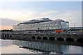
Tower Wharf development, Birkenhead
A four-storey office development which is due to be completed in October 2015, situated alongside Egerton Dock.
The Liverpool Echo offers some insight into the construction: https://web.archive.org/web/20150611225829/http://www.liverpoolecho.co.uk/news/approval-given-new-wirral-waters-7605928
Image: © El Pollock
Taken: 11 Jun 2015
0.01 miles
2
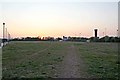
Sunset, Egerton Dock, Birkenhead
This piece of waste ground was formerly part of a railway goods yard. The ballast is still visible, beneath the grass, in places. The central hydraulic tower is visible in the background, to the right of the picture.
Image: © El Pollock
Taken: 21 May 2012
0.03 miles
4
Egerton Bridge
This bridge is between Egerton Dock and Morpeth Dock in Birkenhead. It used to be part of the Birkenhead Packet tourist trail, but does not appear to be open now. This photo was taken in 2004, and the building has deteriorated slightly since then. More information (albeit out-of-date) can be found here: http://www.24hourmuseum.org.uk/liverpool/museum/MW249.html?ixsid=
Image: © Peter Craine
Taken: 22 May 2004
0.05 miles
5
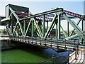
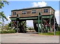
Egerton Bridge (2)
This is an example of a bascule bridge. When it is raised, it is counterbalanced by the large weight shown on the left hand side. In this particular example, the weight is evenly distributed by the rolling action of the bridge (see bottom left hand side). Visit http://www.wirral.gov.uk/ed/Egerton.htm for access details.
Image: © Peter Craine
Taken: 22 May 2004
0.05 miles
6
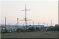
HMS Conway mast, Egerton Dock, Birkenhead
In the background, the Robert Smith Steel gantry is situated on the quayside next to Vittoria Dock.
Image: © El Pollock
Taken: 21 May 2012
0.05 miles
7
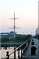
HMS Conway Mast, Egerton Dock, Birkenhead
Image: © El Pollock
Taken: 20 May 2012
0.06 miles
8
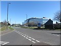
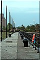
Tower Wharf, Birkenhead
A street in the docks area of Birkenhead. The large office building on the right side of the road is a recent addition.
Image: © Graham Robson
Taken: 2 Apr 2017
0.06 miles
9
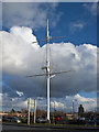
HMS Conway Mizzen Mast
What remained of the HMS Conway Mizzen Mast was rescued by the Conway North West Branch and, with the help of the Conway Vancouver Branch who arranged and delivered a suitably large piece of timber, rebuilt.
Image: © Ian Greig
Taken: 16 Jan 2015
0.07 miles
10
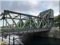
Egerton Bridge
Egerton Bridge is situated between Egerton Dock and Morpeth Dock and is a working example of a bascule bridge. It was built between 1928 and 1931, as one of four similar bascule bridges in the Merseyside docks, replacing an earlier swing bridge. The bridge and the machine house were completely restored in 1993 and opened to the public in 1995.
** Courtesy Wikipedia
Image: © Arthur C Harris
Taken: 19 Jun 2022
0.07 miles