IMAGES TAKEN NEAR TO
Crossfields, CHESTER, CH3 8LG
Introduction
This page details the photographs taken nearby to Crossfields, CH3 8LG by members of the Geograph project.
The Geograph project started in 2005 with the aim of publishing, organising and preserving representative images for every square kilometre of Great Britain, Ireland and the Isle of Man.

There are currently over 7.5m images from over14,400 individuals and you can help contribute to the project by visiting https://www.geograph.org.uk
Image Map
Images are licensed for reuse under creativecommons.org/licenses/by-sa/2.0
Notes
- Clicking on the map will re-center to the selected point.
- The higher the marker number, the further away the image location is from the centre of the postcode.
Image Listing (11 Images Found)
Images are licensed for reuse under creativecommons.org/licenses/by-sa/2.0
Image
Details
Distance
2
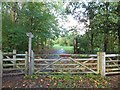
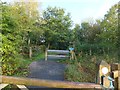
Tarvin Community Wood
The community woodland runs alongside the A51 to the south-west of the village. The board has details of activities in the wood.
Image: © David Smith
Taken: 20 Oct 2011
0.19 miles
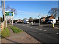
4
Hockenhull Lane in Tarvin
Looking north-eastward.
Image: © Peter Wood
Taken: 17 Nov 2018
0.19 miles
5
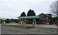
The New Village, Tarvin
New Village Chinese restaurant, Tarvin High Street.
Image: © David Dixon
Taken: 7 Sep 2015
0.19 miles
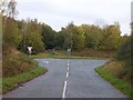
6
Hockenhull Lane
In the village, the lane is a surfaced road. This stops at the community wood, where it becomes a bridleway, crossing a signed cycleway along the A51, and continues as a surfaced road to the south of the main road. Old maps show the lane without interruption.
Image: © David Smith
Taken: 20 Oct 2011
0.20 miles
7
Hockenhull Lane crossing A51
The lane continues as a footpath on the opposite side of the road, then broadens to become a surfaced road in the village of Tarvin
Image: © David Smith
Taken: 20 Oct 2011
0.21 miles
8
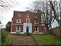
Tarvin Hall
Grade II* listed former manor house: "Formerly manor house, later school, now house: mid-late C18 (graffito date 1776 found during roof repairs) late C19 extension to rear." [https://www.historicengland.org.uk/listing/the-list/list-entry/1330303]
Image: © Dave Dunford
Taken: 14 Apr 2016
0.24 miles
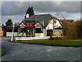
9
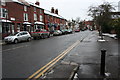
High Street, Tarvin
From the George and Dragon public house.
Image: © Dave Dunford
Taken: 10 Jan 2010
0.24 miles