IMAGES TAKEN NEAR TO
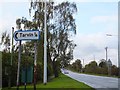
Tarvin, CHESTER, CH3 8JX
Introduction
This page details the photographs taken nearby to CH3 8JX by members of the Geograph project.
The Geograph project started in 2005 with the aim of publishing, organising and preserving representative images for every square kilometre of Great Britain, Ireland and the Isle of Man.

There are currently over 7.5m images from over14,400 individuals and you can help contribute to the project by visiting https://www.geograph.org.uk
Image Map
Images are licensed for reuse under creativecommons.org/licenses/by-sa/2.0
Notes
- Clicking on the map will re-center to the selected point.
- The higher the marker number, the further away the image location is from the centre of the postcode.
Image Listing (27 Images Found)
Images are licensed for reuse under creativecommons.org/licenses/by-sa/2.0
Image
Details
Distance
1
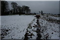
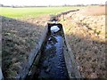
Stream from Tarvin Bridge
This unnamed stream (though named further downstream as Milton Brook) flows under the A54 at Tarvin Sands.
Image: © Dave Dunford
Taken: 10 Jan 2010
0.08 miles
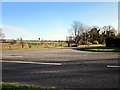
2
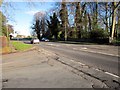
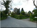
Road junction on the A54 (Kelsall Road)
At the junction of Pool Lane.
Image: © Jeff Buck
Taken: 13 Jan 2012
0.10 miles
3
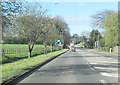
A54 west approaching Tarvin
Junction for Pool Lane ahead
Image: © John Firth
Taken: 15 Apr 2012
0.11 miles
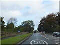
5
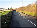
Road junction on the A54 (Kelsall Road)
The east side of the Tarvin Bridge can be seen on the left.
Image: © Jeff Buck
Taken: 13 Jan 2012
0.14 miles
6
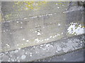
Cut Mark, A54 Bridge nr Tarvin
OS Cut Mark on small bridge on A54, opposite junction with High Street, Tarvin. Number B10689 on Benchmark Database, see: http://www.bench-marks.org.uk/bm36943
Image: © VBForever
Taken: 11 Feb 2011
0.14 miles