IMAGES TAKEN NEAR TO
Hunters Drive, CHESTER, CH3 8EX
Introduction
This page details the photographs taken nearby to Hunters Drive, CH3 8EX by members of the Geograph project.
The Geograph project started in 2005 with the aim of publishing, organising and preserving representative images for every square kilometre of Great Britain, Ireland and the Isle of Man.

There are currently over 7.5m images from over14,400 individuals and you can help contribute to the project by visiting https://www.geograph.org.uk
Image Map
Images are licensed for reuse under creativecommons.org/licenses/by-sa/2.0
Notes
- Clicking on the map will re-center to the selected point.
- The higher the marker number, the further away the image location is from the centre of the postcode.
Image Listing (7 Images Found)
Images are licensed for reuse under creativecommons.org/licenses/by-sa/2.0
Image
Details
Distance

3
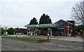
Tarvin Community Woodland
Narrow strip of woodland alongside the A51. Winner of the Countryside and Wildlife Award 2000.
Image: © Dave Dunford
Taken: 14 Apr 2016
0.20 miles
5
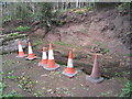
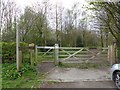
The pinfold, Tarvin
In process of being restored, though why all these cones are required when the whole thing is behind a fence tests the imagination.
Image: © Jonathan Thacker
Taken: 22 Sep 2011
0.22 miles
6
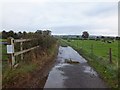
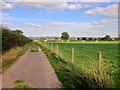
A farm track leading into Tarvin
This track is used for dog-walking and the white sign on the left is a polite and firm request to clean up after dogs to prevent still-births in the cattle. Part of the track is a public bridleway, though the whole of the track to Cross Lanes is used by cyclists and pedestrians.
Image: © David Smith
Taken: 20 Oct 2011
0.22 miles