IMAGES TAKEN NEAR TO
Church Court, CHESTER, CH3 8BG
Introduction
This page details the photographs taken nearby to Church Court, CH3 8BG by members of the Geograph project.
The Geograph project started in 2005 with the aim of publishing, organising and preserving representative images for every square kilometre of Great Britain, Ireland and the Isle of Man.

There are currently over 7.5m images from over14,400 individuals and you can help contribute to the project by visiting https://www.geograph.org.uk
Image Map
Images are licensed for reuse under creativecommons.org/licenses/by-sa/2.0
Notes
- Clicking on the map will re-center to the selected point.
- The higher the marker number, the further away the image location is from the centre of the postcode.
Image Listing (16 Images Found)
Images are licensed for reuse under creativecommons.org/licenses/by-sa/2.0
Image
Details
Distance
1
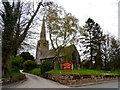
St John the Evangelist, Ashton Hayes
Built in 1849. The architect was E.H. Shellard who designed around 13 churches during this period.
Image: © Bikeboy
Taken: 10 Apr 2014
0.05 miles
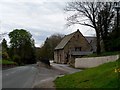
2
Ashton Hayes Women's Institute Hall
Image: © Jonathan Thacker
Taken: 22 Sep 2011
0.05 miles
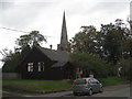
3

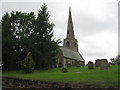
St John the Evangelist's Church, Ashton Hayes
St John the Evangelist's Church is situated to the north of the village and has been designated by English Heritage as a Grade II listed building. It is an active Anglican parish church in the diocese of Chester, the archdeaconry of Chester and the deanery of Chester. St John's became a separate parish in 1849. In that year the church was built to a design by Shellard of Manchester at the expense of William Atkinson. A vestry was added and the chancel was altered in 1900 by Douglas and Minshull, and in 1932 a north chapel by Theodore Fyfe was added.
Image: © Jeff Buck
Taken: 1 Jul 2011
0.05 miles
4
St. John the Evangelist's Church, Ashton Hayes
Originally part of the parish of Tarvin, St John's became a separate parish in 1849. In that year the church was built.
https://en.wikipedia.org/wiki/St_John_the_Evangelist%27s_Church,_Ashton_Hayes
Image: © Brian Deegan
Taken: 10 Sep 2022
0.05 miles
5
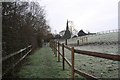
Path to Ashton parish church
A short footpath connecting the Baker Way to the B5393 at the Church of St John the Evangelist, Ashton Keynes. The church was mainly built in 1849 and is a Grade II listed building.
Image: © Dave Dunford
Taken: 16 Jan 2016
0.06 miles
6
St. John the Evangelist, Ashton Hayes
Largely dating from 1849.
Image: © Jonathan Thacker
Taken: 22 Sep 2011
0.06 miles
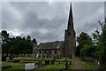
7
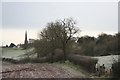
Ashton Hayes parish church
Distant view of the Church of St John the Evangelist at Ashton Hayes, from Gongar Lane. The Baker Way footpath (Chester-Delamere) runs behind the hedge in the foreground. The church is Grade II listed [https://www.historicengland.org.uk/listing/the-list/list-entry/1330310] and was built in 1849.
Image: © Dave Dunford
Taken: 16 Jan 2016
0.06 miles
8
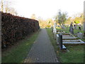
Pathway through the burial ground of St John's Church, Ashton Hayes
Looking north-westward.
Image: © Peter Wood
Taken: 17 Nov 2018
0.07 miles
9
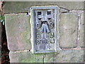
Ordnance Survey Flush Bracket S9634
This bracket can be found on the wall of St John's Church, Ashton. The benchmark height is recorded as being 46.039 metres above sea level.
For more detail see : https://www.bench-marks.org.uk/bm2499
Image: © Peter Wood
Taken: 17 Nov 2018
0.07 miles