IMAGES TAKEN NEAR TO
Chester Road, CHESTER, CH3 6HN
Introduction
This page details the photographs taken nearby to Chester Road, CH3 6HN by members of the Geograph project.
The Geograph project started in 2005 with the aim of publishing, organising and preserving representative images for every square kilometre of Great Britain, Ireland and the Isle of Man.

There are currently over 7.5m images from over14,400 individuals and you can help contribute to the project by visiting https://www.geograph.org.uk
Image Map
Images are licensed for reuse under creativecommons.org/licenses/by-sa/2.0
Notes
- Clicking on the map will re-center to the selected point.
- The higher the marker number, the further away the image location is from the centre of the postcode.
Image Listing (94 Images Found)
Images are licensed for reuse under creativecommons.org/licenses/by-sa/2.0
Image
Details
Distance
1
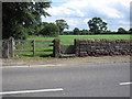
Old stone stile alongside the B5130
There is no footpath associated with this stile shown on the modern O.S. map, however, the 1882 map indicates a track to a well, so I presume the stile was placed there for the same reason.
Image: © John S Turner
Taken: 7 Aug 2009
0.03 miles
2
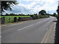
The B5130 and a stone stile
Looking south along the B5130 as it leaves Aldford village. On the left is a gate and old stone stile, which are recorded on the 1882 map as the start of a track to a well. There is no footpath indicated on the modern O.S. map.
Image: © John S Turner
Taken: 7 Aug 2009
0.03 miles
3
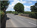
The B5130 going north through Aldford
On the right of the road, just before the field gate and tree, there is an old stone stile.
Image: © John S Turner
Taken: 7 Aug 2009
0.03 miles
4
Green Lake Lane, Aldford
Looking west from the lane's junction with the B5130.
Image: © John S Turner
Taken: 7 Aug 2009
0.04 miles
5
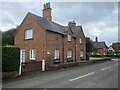
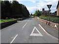
The first house in Aldford
If approaching the village from the south on the B5130.
Image: © John H Darch
Taken: 6 Jun 2022
0.06 miles
6
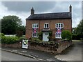
Jubilee cottage
Union flags displayed to celebrate the Queen's Platinum Jubilee, June 2022.
Image: © John H Darch
Taken: 6 Jun 2022
0.07 miles
7
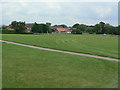
Aldford, the recreation ground
This is a large open space around which the village has been developed.
Image: © Alan Murray-Rust
Taken: 9 Jun 2009
0.07 miles
8
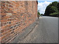
Barn and bench mark in Green Lake Lane
There is a bench mark on this barn near the bottom left hand corner of the photo - Image
Image: © John S Turner
Taken: 7 Aug 2009
0.07 miles

10
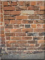
Bench mark in Green Lake Lane
This bench mark is on the barn at Forestry Yard, Green Lake Lane. See also Image
Image: © John S Turner
Taken: 7 Aug 2009
0.08 miles