IMAGES TAKEN NEAR TO
Wilbraham Close, CHESTER, CH2 4TH
Introduction
This page details the photographs taken nearby to Wilbraham Close, CH2 4TH by members of the Geograph project.
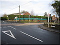
The Geograph project started in 2005 with the aim of publishing, organising and preserving representative images for every square kilometre of Great Britain, Ireland and the Isle of Man.

There are currently over 7.5m images from over14,400 individuals and you can help contribute to the project by visiting https://www.geograph.org.uk
Image Map
Images are licensed for reuse under creativecommons.org/licenses/by-sa/2.0
Notes
- Clicking on the map will re-center to the selected point.
- The higher the marker number, the further away the image location is from the centre of the postcode.
Image Listing (28 Images Found)
Images are licensed for reuse under creativecommons.org/licenses/by-sa/2.0
Image
Details
Distance
1
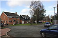
Stile End, Mickle Trafford
Stile End is part of the new estate in the expanding commuter village of Mickle Trafford.
Image: © Jeff Buck
Taken: 23 Feb 2015
0.15 miles
2
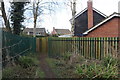
Path into Mickle Trafford
Emerging from the railway underpass into the village.
Image: © Jeff Buck
Taken: 23 Feb 2015
0.15 miles
3
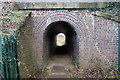
Tunnel under the Chester to Warrington Railway Line
This pedestrian tunnel allows the public footpath from Mickle Trafford to Plemstall Lane to pass under the Chester to Warrington railway line.
Image: © Jeff Buck
Taken: 23 Feb 2015
0.17 miles
4
The A56 (Warrington Road) at Mickle Trafford
The A56 as it passes through the centre of Mickle Trafford.
Wikipedia http://en.wikipedia.org/wiki/Mickle_Trafford
Image: © Jeff Buck
Taken: 14 Feb 2013
0.17 miles
5
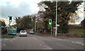
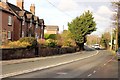
Warrington Road, Mickle Trafford
Warrington Road (A56), at the crossroads with School Lane/Station Lane at Mickle Trafford.
Image: © David Dixon
Taken: 9 Nov 2010
0.17 miles
6
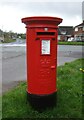
Elizabeth II postbox on Warrington Road
Postbox No. CH2 132.
See Image] for context.
Image: © JThomas
Taken: 20 Mar 2024
0.17 miles
7
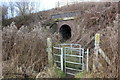
Stile and tunnel to Mickle Trafford
The footpath to the village passes through the tunnel under the Chester to Warrington railway line.
Image: © Jeff Buck
Taken: 23 Feb 2015
0.18 miles
8
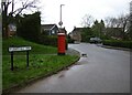
Plemstall Way
Showing position of Postbox No. CH2 132.
See Image] for postbox.
Image: © JThomas
Taken: 20 Mar 2024
0.18 miles
9
Crossroads in Mickle Trafford
Looking from Station Lane towards the A56 through Mickle Trafford. There may be an early First Geodetic Levelling bench mark on the low stone wall round the corner, but the wall is covered with ivy at the relevant point, so if it is there it is not accessible at the moment.
Image: © John S Turner
Taken: 16 Jan 2010
0.18 miles
10
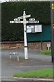
Old Direction Sign - Signpost by the A56, Warrington Road, Mickle Trafford parish
Pawn finial - 4 arms; Old CCC octagonal by the A56, in parish of Mickle Trafford (Chester District), Warrington Road junction with School Lane.
To be surveyed
Milestone Society National ID: CH_SJ4469
Image: © Milestone Society
Taken: Unknown
0.18 miles