IMAGES TAKEN NEAR TO
Heathcote Close, CHESTER, CH2 2RB
Introduction
This page details the photographs taken nearby to Heathcote Close, CH2 2RB by members of the Geograph project.
The Geograph project started in 2005 with the aim of publishing, organising and preserving representative images for every square kilometre of Great Britain, Ireland and the Isle of Man.

There are currently over 7.5m images from over14,400 individuals and you can help contribute to the project by visiting https://www.geograph.org.uk
Image Map
Images are licensed for reuse under creativecommons.org/licenses/by-sa/2.0
Notes
- Clicking on the map will re-center to the selected point.
- The higher the marker number, the further away the image location is from the centre of the postcode.
Image Listing (112 Images Found)
Images are licensed for reuse under creativecommons.org/licenses/by-sa/2.0
Image
Details
Distance
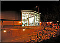
1
Bridge over the rail path
Looking along the Chester rail path with it passing under Victoria Road.
Image: © DS Pugh
Taken: 8 Aug 2020
0.02 miles
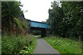
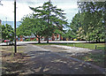
2
Access point on the Millennium Greenway
The access point leads to Liverpool Road. The road bridge carries the A5116 (Liverpool Road) over the Millennium Greenway.
Image: © Jeff Buck
Taken: 18 Jun 2012
0.03 miles
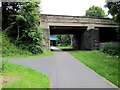
3
Cycle path
Formerly the Mickle Trafford to Deeside Railway. See: http://www.chesterwalls.info/railstroll/railfacts.html
Image: © Bill Harrison
Taken: 7 Apr 2011
0.04 miles
4
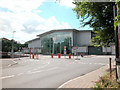
Total Fitness Chester
On Liverpool Road. Built on the site of a former coalyard and builders merchant, alongside the former Mickle Trafford to Deeside railway track
Image: © Dennis Turner
Taken: 3 Aug 2005
0.07 miles
5
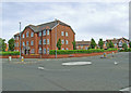
The Heywoods
Housing development in Liverpool Road built on a former industrial site used for the manufacture of window frames. The name of the manufacturer was Heywood Williams.
Image: © Dennis Turner
Taken: 3 Jun 2008
0.07 miles
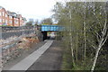
6
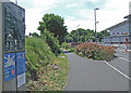
Cycleway access
Access to National Cycle Route 5. The sign indicates that this section 8 mile section is Phase 1 Chester to Connah's Quay Railway Path, forming part of the North Wales coastal route from Chester to Bangor and Holyhead.
Image: © Dennis Turner
Taken: 8 Jun 2008
0.07 miles
7
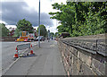
Road works
Re-surfacing of Liverpool Road.
Image: © Dennis Turner
Taken: 6 Jul 2008
0.07 miles
8
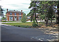
Queen's School
Sandford House of the Queen's School junior department in the Liverpool Road.
Image: © Dennis Turner
Taken: 8 Jun 2008
0.07 miles
9
Queen's School
Needham House of Queen's School junior department in Liverpool Road.
Image: © Dennis Turner
Taken: 8 Jun 2008
0.07 miles