IMAGES TAKEN NEAR TO
Broadway East, CHESTER, CH2 2DP
Introduction
This page details the photographs taken nearby to Broadway East, CH2 2DP by members of the Geograph project.
The Geograph project started in 2005 with the aim of publishing, organising and preserving representative images for every square kilometre of Great Britain, Ireland and the Isle of Man.

There are currently over 7.5m images from over14,400 individuals and you can help contribute to the project by visiting https://www.geograph.org.uk
Image Map
Images are licensed for reuse under creativecommons.org/licenses/by-sa/2.0
Notes
- Clicking on the map will re-center to the selected point.
- The higher the marker number, the further away the image location is from the centre of the postcode.
Image Listing (26 Images Found)
Images are licensed for reuse under creativecommons.org/licenses/by-sa/2.0
Image
Details
Distance
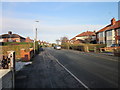
1
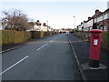
Sandon Road, Chester
Sandon Road near the junction with Dicksons Drive.
Image: © Jeff Buck
Taken: 15 Jan 2015
0.14 miles
2
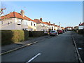
Dicksons Drive, Chester
Dicksons Drive approaching the junction with The Crescent seen on the left.
Image: © Jeff Buck
Taken: 15 Jan 2015
0.16 miles
3
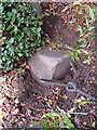
War department boundary stone #2, Brook Lane
This stone is half buried at the corner of Western Approach and Brook Lane. Although no inscription is visible it is in the correct location for the War Department stone #2 that is marked on the 1936 O.S. maps. Several other WD stones are shown surrounding the area of the Western Approach properties, which were probably associated with Western Command, but the other stones are either missing or inaccessible. See also Image
Milestone Society National ID: CH_WDCHES02em.
Image: © John S Turner
Taken: 15 Oct 2017
0.18 miles
4
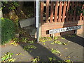
Western Approach and a boundary stone
The junction of Western Approach and Brook Lane. The half-buried square stone just to the right of the shrub is the War Department boundary stone #2 Image There is no inscription visible on the stone, but it is marked at this location on the 1936 O.S. map.
Image: © John S Turner
Taken: 15 Oct 2017
0.18 miles
5
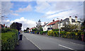
Shepherd's Lane, Chester
Shepherd's Lane from the junction with Dicksons Drive.
Image: © Jeff Buck
Taken: 15 Jan 2015
0.18 miles
7
The Crescent, Chester
The Crescent in Newton near the junction with Dicksons Drive.
Image: © Jeff Buck
Taken: 15 Jan 2015
0.19 miles
8
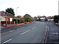
Ellesmere Avenue, Chester
Ellesmere Avenue heading from the junction with Dicksons Drive.
Image: © Jeff Buck
Taken: 15 Jan 2015
0.20 miles
9
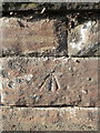
Bench mark in Brook Lane, Chester
This Ordnance Survey bench mark is on the sandstone wall in front of 'Coniston' in Brook Lane. See also Image
Image: © John S Turner
Taken: 15 Oct 2017
0.20 miles
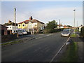
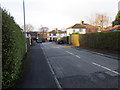
10
Dicksons Drive, Chester
Dicksons Drive in Newton, Chester.
Image: © Jeff Buck
Taken: 15 Jan 2015
0.20 miles