IMAGES TAKEN NEAR TO
St. Martins Way, CHESTER, CH1 2NR
Introduction
This page details the photographs taken nearby to St. Martins Way, CH1 2NR by members of the Geograph project.
The Geograph project started in 2005 with the aim of publishing, organising and preserving representative images for every square kilometre of Great Britain, Ireland and the Isle of Man.

There are currently over 7.5m images from over14,400 individuals and you can help contribute to the project by visiting https://www.geograph.org.uk
Image Map
Images are licensed for reuse under creativecommons.org/licenses/by-sa/2.0
Notes
- Clicking on the map will re-center to the selected point.
- The higher the marker number, the further away the image location is from the centre of the postcode.
Image Listing (2296 Images Found)
Images are licensed for reuse under creativecommons.org/licenses/by-sa/2.0
Image
Details
Distance
1
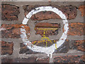
Bench mark on #7 St Martins Way
Someone must have thought this bench mark was worth highlighting! The mark is on the north end of the listed #7 St Martins Way - http://list.english-heritage.org.uk/resultsingle.aspx?uid=1376380 The town house was built in 1777 and its last identity was the Cromwell Court Hotel. Standing next to St Martins Way, the busy inner ring road, this potentially lovely old house has been closed up for several years. The lane past the bench mark on the north side of the building was once the rear entrance to Chester Royal Infirmary.
Image: © John S Turner
Taken: 21 Nov 2010
0.00 miles
2
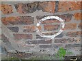
Ordnance Survey Cut Mark
This OS cut mark can be found on No9 St Martins Way. It marks a point 22.378m above mean sea level.
Image: © Adrian Dust
Taken: 13 Sep 2022
0.00 miles
3
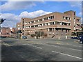
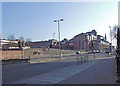
St Martins House prior to Demolition
Situated on the corner of St Martins Way and Princess Street this office block has stood empty and derelict for probably fifteen years. At last it is being demolished as part of the Northgate Development project. See also Image
Image: © John S Turner
Taken: 14 Mar 2007
0.02 miles
4
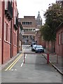
Bedward Row and St Martins House
Looking along Bedward Row, and across St Martins Way, the inner ring road, towards the derelict St Martins House. St Martins House is being demolished as part of the Northgate Development project, and just to its right is the tower and spire of the historic town hall, which isn't being demolished.
Image: © John S Turner
Taken: 20 May 2007
0.02 miles
5
Nicholas Street
Part of the inner ring road.
Image: © Dennis Turner
Taken: 16 Feb 2008
0.02 miles
6
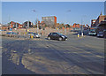
Princess Street junction
With Nicholas Street. The site in the centre of the picture is awaiting re-development.
Image: © Dennis Turner
Taken: 16 Feb 2008
0.02 miles
7
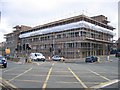
St Martins House being prepared for Demolition
This derelict office block, situated on the corner of St Martins Way and Princess Street, is being prepared for demolition. Demolishing the building safely without closing the road requires careful preparation and skill.
See also Image, and the next stage Image
Image: © John S Turner
Taken: 24 Jul 2007
0.03 miles
8
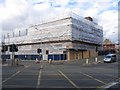
St Martins House being Demolished
This derelict office building, on the corner of St Martins Way and Princess Street, is being demolished as part of the Northgate Development project. The side away from the road has been demolished by a Komatsu PC600LC demolition machine, however, this side is being demolished by hand to allow the road to remain open. See also Image
Image: © John S Turner
Taken: 12 Aug 2007
0.03 miles
10
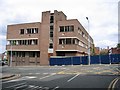
St Martins House, Princess Street
Derelict for many years this prominent office block is now being demolished as part of the Northgate Development of Chester city centre. It is estimated the entire project will take about four years. Viewed from Trinity Street, Princess Street crosses the photo and joins St Martins Way out of sight to the left.
Image: © John S Turner
Taken: 20 May 2007
0.04 miles