1
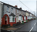
Cenydd Terrace Senghenydd
Cenydd Terrace is the northernmost residential street in Senghenydd, adjacent to moorland. http://www.geograph.org.uk/photo/2920180
The 37 houses in Cenydd Terrace are all in this 200 metre long row on the north side of the street.
Image: © Jaggery
Taken: 27 Apr 2012
0.03 miles
2
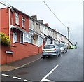
Cenydd Terrace in Senghenydd
At the northern edge of the village, Cenydd Terrace houses are all one side of the dead-end street.
They face the backs of Graig Terrace houses on the right.
Image: © Jaggery
Taken: 15 Mar 2019
0.04 miles
3
Side Valley above Senghenydd
The valley from the former mining village leads up to the Rhymney Valley ridgeline. In the foreground is the top of a drystone dyke which surrounds pasture land.
Image: © Colin Smith
Taken: 24 Sep 2006
0.06 miles
4
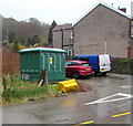
Cenydd Terrace electricity substation, Senghenydd
The green cabinet is a Western Power Distribution electricity substation.
Its identifier is CENYDD TERRACE S/S 54-2578.
Image: © Jaggery
Taken: 15 Mar 2019
0.08 miles
5
Senghenydd's Four Terraces
The terraces, in which it is claimed that every home had a victim in the Universal Colliery disaster of 1913, are seen from the Rhymney Valley Ridgeway Path.
Image: © Gareth James
Taken: 19 Jan 2014
0.08 miles
6
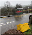
Bus stop and shelter near Cenydd Terrace, Senghenydd
In March 2019 the bus stop sign on the right shows that
this is a stop on route B to Caerphilly and route X to Cardiff.
An overturned salt/grit box is near the camera.
Image: © Jaggery
Taken: 15 Mar 2019
0.08 miles
7
Woodland Terrace Senghenydd
This is the SW end of Woodland Terrace, a 120 metre long row of 22 houses.
All the houses in Woodland Terrace are on this side of the street.
Image: © Jaggery
Taken: 27 Apr 2012
0.09 miles
8
Phillips Terrace Senghenydd
This is the SW end of Phillips Terrace, a 110 metre long row of 20 houses.
All the houses in Phillips Terrace on this side of the street.
Image: © Jaggery
Taken: 27 Apr 2012
0.09 miles
9
Graig Terrace, Senghenydd
This is the SW end of Graig Terrace, a 220 metre long row of 38 houses.
All the houses in Graig Terrace are on this side of the street.
Image: © Jaggery
Taken: 27 Apr 2012
0.09 miles
10
Moorland stream, Senghenydd
During a wet period in late April 2012, water flows vigorously down moorland
http://www.geograph.org.uk/photo/2920180 near the northern edge of residential Senghenydd.
Image: © Jaggery
Taken: 27 Apr 2012
0.11 miles


