IMAGES TAKEN NEAR TO
Bronmynydd, CAERPHILLY, CF83 4ER
Introduction
This page details the photographs taken nearby to Bronmynydd, CF83 4ER by members of the Geograph project.
The Geograph project started in 2005 with the aim of publishing, organising and preserving representative images for every square kilometre of Great Britain, Ireland and the Isle of Man.

There are currently over 7.5m images from over14,400 individuals and you can help contribute to the project by visiting https://www.geograph.org.uk
Image Map
Images are licensed for reuse under creativecommons.org/licenses/by-sa/2.0
Notes
- Clicking on the map will re-center to the selected point.
- The higher the marker number, the further away the image location is from the centre of the postcode.
Image Listing (79 Images Found)
Images are licensed for reuse under creativecommons.org/licenses/by-sa/2.0
Image
Details
Distance
2
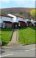
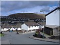
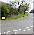
Bronmynydd ramp, Abertridwr
From the south side of the Bronmynydd roadway,
the ramp ascends to Bronmynydd houses.
Image: © Jaggery
Taken: 28 Mar 2019
0.02 miles
3
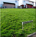
Welsh-only name sign on a grass bank, Bronmynydd, Abertridwr
Bronmynydd does not have an equivalent English name. Some references wrongly show Bronmynnyd.
Image: © Jaggery
Taken: 28 Mar 2019
0.03 miles
4
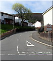
Ilan Road, Abertridwr
Ilan Road ascends from Aberfawr Road and Bronmynydd.
The sign on the right shows Humps for 590 yards and its Welsh equivalent.
Image: © Jaggery
Taken: 28 Mar 2019
0.03 miles
5
Yellow grit box, Bronmynydd, Abertridwr
Opposite the Ilan Road junction.
Image: © Jaggery
Taken: 28 Mar 2019
0.03 miles
6
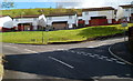
Bronmynydd houses, Abertridwr
Viewed from the southern end of Aberfawr Road. Some sources show the incorrect spelling "Bronmynnyd"
Image: © Jaggery
Taken: 1 May 2012
0.04 miles
7

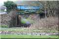
East side of Aberfawr Road bridge, Abertriwdr
The bridge carries Aberfawr Road over a combined footpath & cycleway on the route of a dismantled railway. Passenger train services in this area ended in 1964.
Image: © Jaggery
Taken: 28 Mar 2019
0.05 miles
8
Aber Cycleway goes under Aberfawr Road
Cycleway (NCR 475) circumvents a grass mound (camera position) and watercourse channel to go under the bridge over the former railway track bed.
Image: © M J Roscoe
Taken: 11 Apr 2018
0.05 miles
9
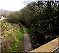
Former railway route in Abertridwr
Looking east from this https://www.geograph.org.uk/photo/6118333 bridge. Passenger services in this area ended in 1964.
Image: © Jaggery
Taken: 28 Mar 2019
0.05 miles
10
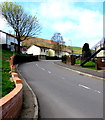
Up Ilan Road, Abertridwr
From the corner of Bronmynydd, Ilan Road ascends
towards the Cefn Ilan Road junction ahead on the left.
Image: © Jaggery
Taken: 28 Mar 2019
0.05 miles