IMAGES TAKEN NEAR TO
Gaer Place, HENGOED, CF82 8EQ
Introduction
This page details the photographs taken nearby to Gaer Place, CF82 8EQ by members of the Geograph project.
The Geograph project started in 2005 with the aim of publishing, organising and preserving representative images for every square kilometre of Great Britain, Ireland and the Isle of Man.

There are currently over 7.5m images from over14,400 individuals and you can help contribute to the project by visiting https://www.geograph.org.uk
Image Map
Images are licensed for reuse under creativecommons.org/licenses/by-sa/2.0
Notes
- Clicking on the map will re-center to the selected point.
- The higher the marker number, the further away the image location is from the centre of the postcode.
Image Listing (127 Images Found)
Images are licensed for reuse under creativecommons.org/licenses/by-sa/2.0
Image
Details
Distance
1
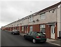
Long row of houses, St Cattwg's Avenue, Gelligaer
A view to the SW from the Heol Edward Lewis end.
Image: © Jaggery
Taken: 10 May 2013
0.07 miles
2
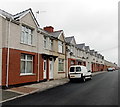
St Cattwg's Avenue houses, Gelligaer
Looking NE from the Aneurin Bevan Avenue end.
Image: © Jaggery
Taken: 10 May 2013
0.07 miles
3
Heol Edward Lewis in Gelligaer
Looking to the WNW along Heol Edward Lewis towards the Greenhill Place junction.
Image: © Jaggery
Taken: 14 Feb 2019
0.08 miles
4
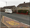
Aneurin Bevan Avenue houses, Gelligaer
When a name sign disagrees with the name shown on a map, it is often difficult to determine which is correct. On this occasion there was no problem. The street name sign on the house on the right of the caravan shows ANEURN BEVAN AVE.
Image: © Jaggery
Taken: 10 May 2013
0.09 miles
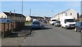
5
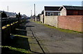
Back lane in Gelligaer
Between St Cattwg's Avenue and Haman Place viewed from Heol Edward Lewis.
Image: © Jaggery
Taken: 14 Feb 2019
0.10 miles
6
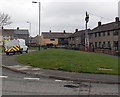
Man up a pole, Gelligaer
A Kelly Communications van is parked in Aneurin Bevan Avenue.
Nearby, a Kelly Communications engineer is working at the top of a telephone pole.
Image: © Jaggery
Taken: 10 May 2013
0.11 miles
7
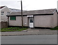
Ashley's Barber Shop, Gelligaer
Located in a single-storey building in Heol Edward Lewis, near the corner of St Cattwg's Avenue.
Image: © Jaggery
Taken: 10 May 2013
0.11 miles
8
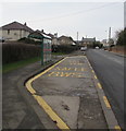
Church Road bus stop and shelter, Gelligaer
The stop alongside the B4254 Church Road is on bus route C17 to Caerphilly.
Image: © Jaggery
Taken: 13 Feb 2019
0.13 miles
9
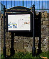
Gelligaer & Penybryn Partnership noticeboard in Gelligaer
Located here https://www.geograph.org.uk/photo/6059757 outside St Catwg Community Hall.
The name on the board is also in Welsh.
Image: © Jaggery
Taken: 14 Feb 2019
0.13 miles
10
Public footpath signpost in Gelligaer
Pointing away from Church Road.
Image: © Jaggery
Taken: 14 Feb 2019
0.14 miles