IMAGES TAKEN NEAR TO
Castle Hill, HENGOED, CF82 8EB
Introduction
This page details the photographs taken nearby to Castle Hill, CF82 8EB by members of the Geograph project.
The Geograph project started in 2005 with the aim of publishing, organising and preserving representative images for every square kilometre of Great Britain, Ireland and the Isle of Man.

There are currently over 7.5m images from over14,400 individuals and you can help contribute to the project by visiting https://www.geograph.org.uk
Image Map (Loading...)


Getting Data...Please wait
Leaflet Map data © OpenStreetMap
Images are licensed for reuse under creativecommons.org/licenses/by-sa/2.0
Notes
- Clicking on the map will re-center to the selected point.
- The higher the marker number, the further away the image location is from the centre of the postcode.
Image Listing (122 Images Found)
Images are licensed for reuse under creativecommons.org/licenses/by-sa/2.0
Image
Details
Distance
1
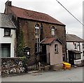
Horeb Chapel, Gelligaer
The nameboard http://www.geograph.org.uk/photo/3455199 on the Castle Hill building shows Horeb Welsh Baptist Chapel 1848.
Image: © Jaggery
Taken: 10 May 2013
0.00 miles
2
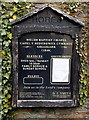
Horeb chapel nameboard, Gelligaer
The board is on the wall here. http://www.geograph.org.uk/photo/3455198
Image: © Jaggery
Taken: 10 May 2013
0.01 miles
3
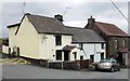
Chapel Cottages, Gelligaer
The Castle Hill cottages are between the entrance http://www.geograph.org.uk/photo/3455205 to Gelligaer Cemetery on the left and Horeb chapel http://www.geograph.org.uk/photo/3455198 on the right.
Image: © Jaggery
Taken: 10 May 2013
0.01 miles
4
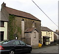
Derelict former Horeb chapel, Castle Hill, Gelligaer
Viewed in February 2019. The chapel exterior has deteriorated since this photo https://www.geograph.org.uk/photo/3455198 taken in May 2013.
Image: © Jaggery
Taken: 13 Feb 2019
0.01 miles
5

Overgrown Horeb information board, Castle Hill, Gelligaer
Outside this https://www.geograph.org.uk/photo/6067786 derelict former chapel in February 2019.
Image: © Jaggery
Taken: 13 Feb 2019
0.01 miles
6

Derelict former chapel, Castle Hill, Gelligaer
The exterior of the former Horeb chapel is deteriorating in February 2019.
Image: © Jaggery
Taken: 13 Feb 2019
0.01 miles
7
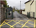
Entrance to Gelligaer Cemetery
Viewed from Castle Hill. One of 10 cemeteries managed by Caerphilly County Borough Council, Gelligaer cemetery has been in use since 1935.
Image: © Jaggery
Taken: 10 May 2013
0.01 miles
8

North along Castle Hill, Gelligaer
Viewed from near the B4254 junction looking towards an entrance to Gelligaer Cemetery.
Image: © Jaggery
Taken: 13 Feb 2019
0.02 miles
9

Yew Tree cottages, Gelligaer
Short row of houses on the north side of Castle Hill.
Image: © Jaggery
Taken: 14 Feb 2019
0.02 miles
10
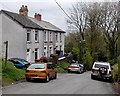
Yew Tree Cottages, Gelligaer
The row of three houses is in Castle Hill near Horeb Chapel. http://www.geograph.org.uk/photo/3455198
Image: © Jaggery
Taken: 10 May 2013
0.03 miles