1
Tabor United Reformed Church (detail)
http://www.geograph.org.uk/photo/1711988
Image: © Robin Drayton
Taken: 23 Jan 2010
0.01 miles
2
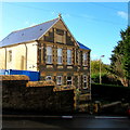
Tabor United Reformed Church, Maesycwmmer
Established in 1829 as Tabor Welsh Congregational Church, this large building dates from 1876.
It became part of the United Reformed Church in 1971, eventually closing in 2003.
For a close up of the inscription above the entrance see http://www.geograph.org.uk/photo/1712011 .
Image: © Robin Drayton
Taken: 23 Jan 2010
0.01 miles
3
West Avenue, Maesycwmmer
Ascending from Tabor Road towards the North Avenue crossroads.
The Old Police Station https://www.geograph.org.uk/photo/5991870 is on the right.
Image: © Jaggery
Taken: 30 Nov 2018
0.02 miles
4
Tabor Chapel, Maesycwmmer
Image: © John Lord
Taken: 24 Aug 2017
0.02 miles
5
Former village post office, Maesycwmmer
On the corner of West Avenue and North Avenue viewed in November 2018.
An August 2011 Google Earth Street View shows a post office on this corner.
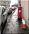
The red pillarbox https://www.geograph.org.uk/photo/5991861 behind the car on the left is a reminder of the building's former use.
Image: © Jaggery
Taken: 30 Nov 2018
0.02 miles
6
Queen Elizabeth II pillarbox, West Avenue, Maesycwmmer
Behind the car on the left here https://www.geograph.org.uk/photo/5991857 outside the former village post office.
Image: © Jaggery
Taken: 30 Nov 2018
0.02 miles
7
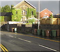
Wheelie bins, Tabor Road, Maesycwmmer
Caerphilly County Borough Council wheelie bins awaiting emptying on November 30th 2018.
Derelict former Tabor church https://www.geograph.org.uk/photo/5991895 is in the background.
Image: © Jaggery
Taken: 30 Nov 2018
0.02 miles
8
Old Police Station, Maesycwmmer
The West Avenue side of the house on the corner of Tabor Road.
The word POLICE remains legible on the faded tablet near the top of the building.
The year on the tablet is indistinct - it appears to start with 18.
The final two digits may be 88 89 98 or 99.
Image: © Jaggery
Taken: 30 Nov 2018
0.02 miles
9
Tabor Chapel, Maesycwmmer
Image: © John Lord
Taken: 24 Aug 2017
0.03 miles
10
Overgrown former Tabor church, Maesycwmmer
The derelict building above the east side of Tabor Road dates from 1876.
The building was Grade II(star) listed in 1997.
Listed status is no guarantee that a building will be kept in a good state of repair.
Image: © Jaggery
Taken: 30 Nov 2018
0.03 miles


