IMAGES TAKEN NEAR TO
Park Lane, HENGOED, CF82 7BX
Introduction
This page details the photographs taken nearby to Park Lane, CF82 7BX by members of the Geograph project.
The Geograph project started in 2005 with the aim of publishing, organising and preserving representative images for every square kilometre of Great Britain, Ireland and the Isle of Man.

There are currently over 7.5m images from over14,400 individuals and you can help contribute to the project by visiting https://www.geograph.org.uk
Image Map
Images are licensed for reuse under creativecommons.org/licenses/by-sa/2.0
Notes
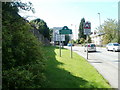
- Clicking on the map will re-center to the selected point.
- The higher the marker number, the further away the image location is from the centre of the postcode.
Image Listing (157 Images Found)
Images are licensed for reuse under creativecommons.org/licenses/by-sa/2.0
Image
Details
Distance
1
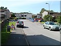
Coed-yr-Haf, Ystrad Mynach
Coed-yr-Haf is a residential road which follows a roughly T-shaped course. This view is from the bottom of the T, looking towards the junction with the top of the T.
Image: © Jaggery
Taken: 27 Aug 2010
0.03 miles
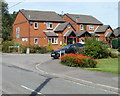
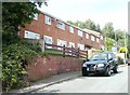
2
Tredomen Villas
Six semi-detached houses named Tredomen Villas, located on the north side of the A472.
Image: © Jaggery
Taken: 27 Aug 2010
0.08 miles
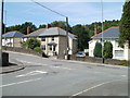
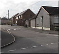
3
Corner of Brynmynach Avenue and Fferm-y-Bryn, Ystrad Mynach
Fferm-y-Bryn houses viewed across Brynmynach Avenue.
Image: © Jaggery
Taken: 27 Aug 2010
0.09 miles
4
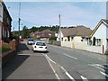
Change of house type, Brynmynach Avenue, Ystrad Mynach
A long line of semi-detached bungalows on the east side of the avenue ends ahead, at the corner of Brynview Avenue. Beyond that point are distinctively-roofed two-storey houses.
Image: © Jaggery
Taken: 27 Aug 2010
0.09 miles
5
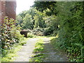
Track into Coed-y-Twyn woods
At the north end of Derwen Close, http://www.geograph.org.uk/photo/2064430 a track leads into a wooded area named Coed-y-Twyn.
Image: © Jaggery
Taken: 27 Aug 2010
0.11 miles
6
Upper part of Derwen Close, Ystrad Mynach
At the top end of the close, a track http://www.geograph.org.uk/photo/2064396 leads into Coed-y-Twyn woods. The lower end of the close http://www.geograph.org.uk/photo/2064387 connects with Brynmynach Avenue. http://www.geograph.org.uk/photo/2064376
Image: © Jaggery
Taken: 27 Aug 2010
0.11 miles
7
Brynmynach Avenue, Tredomen
Viewed across the A472. Painted white triangles draw attention
to a speed bump, one of many bumps on Brynmynach Avenue.
Image: © Jaggery
Taken: 26 Nov 2018
0.11 miles
8
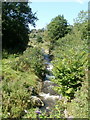
Nant Caeach flows near Nelson Road, Ystrad Mynach
The stream flows towards the Rhymney River, about 700 metres behind the camera.
Image: © Jaggery
Taken: 27 Aug 2010
0.12 miles
9
NE edge of Tredomen
Nelson Road (A472) reaches Tredomen. Ahead is Tredomen Park and Caerphilly County Borough Council's new headquarters building, Penallta House. http://www.geograph.org.uk/photo/2065000
Image: © Jaggery
Taken: 27 Aug 2010
0.12 miles
10
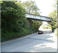
Railway bridge across Nelson Road
A single track railway line crosses the A472 Nelson Road a few metres from the NE edge of Tredomen. http://www.geograph.org.uk/photo/2065217 The line was formerly used for passenger services, which ceased in 1964. It is now shown on maps as "Mineral Railway"
Image: © Jaggery
Taken: 27 Aug 2010
0.12 miles