IMAGES TAKEN NEAR TO
St. Margarets Way, BARGOED, CF81 9GB
Introduction
This page details the photographs taken nearby to St. Margarets Way, CF81 9GB by members of the Geograph project.
The Geograph project started in 2005 with the aim of publishing, organising and preserving representative images for every square kilometre of Great Britain, Ireland and the Isle of Man.

There are currently over 7.5m images from over14,400 individuals and you can help contribute to the project by visiting https://www.geograph.org.uk
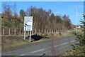
Image Map
Images are licensed for reuse under creativecommons.org/licenses/by-sa/2.0
Notes
- Clicking on the map will re-center to the selected point.
- The higher the marker number, the further away the image location is from the centre of the postcode.
Image Listing (18 Images Found)
Images are licensed for reuse under creativecommons.org/licenses/by-sa/2.0
Image
Details
Distance
1
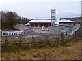
Aberbargoed Community Fire and Rescue Station
A new fire station to the south of Aberbargoed is nearing completion.
It will eventually replace the existing fire stations in Cefn Forest http://www.geograph.org.uk/photo/467196 and Bargoed http://www.geograph.org.uk/photo/467177 .
Image: © Robin Drayton
Taken: 23 Jan 2014
0.02 miles
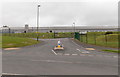
2
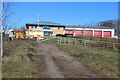
Aberbargoed Fire Station
The station is just outside Bargoed Woodland Park, foreground, and on a link road between two A roads.
Image: © M J Roscoe
Taken: 16 Mar 2021
0.03 miles
3
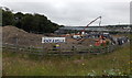
Work progressing on the new Aberbargoed Community Fire and Rescue Station
This is an early July 2013 view of the Knox & Wells building site on the corner of the A4049 and the connecting road to the A469. The fire station being built here is scheduled to open in January 2014.
The fire stations in Cefn Fforest and Bargoed will then close.
Image: © Jaggery
Taken: 4 Jul 2013
0.04 miles
4

Gwaelodywaun Villas, Aberbargoed
Viewed across the A4049 Pengam Road. The houses are opposite St Margaret's Business Park.
Image: © Jaggery
Taken: 4 Jul 2013
0.04 miles
5
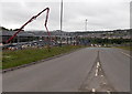
Link road from the A4049 in Aberbargoed to the A469 in Bargoed
A view from the Aberbargoed end of the link road past work in progress on a new fire station. http://www.geograph.org.uk/photo/3540420
Image: © Jaggery
Taken: 4 Jul 2013
0.05 miles
6
Road direction sign, Aberbargoed
Bilingual sign on link road between A469 and A4049. The land beyond the fence is part of Bargoed Woodland Park, all on reclaimed land.
Image: © M J Roscoe
Taken: 16 Mar 2021
0.07 miles
7

Jean's Cafe, Aberbargoed
The cafe is in St Margaret's Business Park, facing the A4049 Pengam Road.
Image: © Jaggery
Taken: 4 Jul 2013
0.08 miles
8

NW corner of St Margaret's Business Park, Aberbargoed
Viewed from the A4049 Pengam Road.
Image: © Jaggery
Taken: 4 Jul 2013
0.08 miles
9
International Greetings factory, Aberbargoed
Viewed across the A4049. This side of the factory extends for about 170 metres.
Image: © Jaggery
Taken: 4 Jul 2013
0.13 miles
10

Southern boundary of Aberbargoed
The A4049 from Pengam via Britannia reaches Aberbargoed, a small town in Caerphilly County Borough.
Image: © Jaggery
Taken: 4 Jul 2013
0.14 miles