IMAGES TAKEN NEAR TO
Penbryn Coch, PONTYCLUN, CF72 9FA
Introduction
This page details the photographs taken nearby to Penbryn Coch, CF72 9FA by members of the Geograph project.
The Geograph project started in 2005 with the aim of publishing, organising and preserving representative images for every square kilometre of Great Britain, Ireland and the Isle of Man.

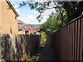
There are currently over 7.5m images from over14,400 individuals and you can help contribute to the project by visiting https://www.geograph.org.uk
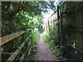
Image Map
Images are licensed for reuse under creativecommons.org/licenses/by-sa/2.0
Notes
- Clicking on the map will re-center to the selected point.
- The higher the marker number, the further away the image location is from the centre of the postcode.
Image Listing (13 Images Found)
Images are licensed for reuse under creativecommons.org/licenses/by-sa/2.0
Image
Details
Distance
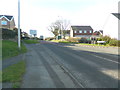
3
ENE along Llanharry Road, Llanharry
Viewed past the Birchgrove junction in April 2021. Ahead for Llechau and Brynsadler.
Image: © Jaggery
Taken: 13 Apr 2021
0.18 miles
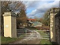
4
Valeways Millennium Heritage Trail near Llanharry
Open land between new housing estates.
Image: © John Light
Taken: 24 Sep 2011
0.18 miles
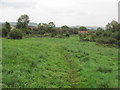
5
Llwybr yn Llanharri / Path in Llanharry
Llwybr cyhoeddus yn cyrraedd ystad o dai yn Llanharri.
A public footpath approaching a housing estate in Llanharry (trans. church of Harri).
Image: © Alan Richards
Taken: 28 Jul 2019
0.20 miles
6
Llwybr i Heol y Fforest / Path to Fforest Road
Llwybr cyhoeddus yn arwain at Heol y Fforest.
A public footpath heading towards Fforest Road.
Image: © Alan Richards
Taken: 28 Jul 2019
0.22 miles
7
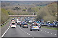
Rhondda Cynon Taf : M4 Motorway
The M4 Motorway heading eastbound as it passes through the Rhondda Cynon Taf area.
Image: © Lewis Clarke
Taken: 11 Apr 2014
0.22 miles
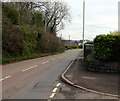
8
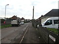
South along Birchgrove, Llanharry
From the corner of Llanharry Road.
Image: © Jaggery
Taken: 13 Apr 2021
0.23 miles
9
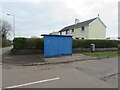
Blue bus shelter on a Llanharry corner
On the Birchgrove side of the corner of Llanharry Road.
A Royal Mail drop box https://www.geograph.org.uk/photo/6806175 is on the right.
Image: © Jaggery
Taken: 13 Apr 2021
0.23 miles
10
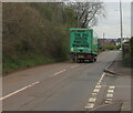
The Big Green Parcel Machine, Llanharry
Green Tuffnells Parcels Express lorry on Llanharry Road in April 2021.
Image: © Jaggery
Taken: 13 Apr 2021
0.23 miles