IMAGES TAKEN NEAR TO
Heol-y-Mynydd, COWBRIDGE, CF71 7SW
Introduction
This page details the photographs taken nearby to Heol-y-Mynydd, CF71 7SW by members of the Geograph project.
The Geograph project started in 2005 with the aim of publishing, organising and preserving representative images for every square kilometre of Great Britain, Ireland and the Isle of Man.

There are currently over 7.5m images from over14,400 individuals and you can help contribute to the project by visiting https://www.geograph.org.uk
Image Map
Images are licensed for reuse under creativecommons.org/licenses/by-sa/2.0
Notes
- Clicking on the map will re-center to the selected point.
- The higher the marker number, the further away the image location is from the centre of the postcode.
Image Listing (25 Images Found)
Images are licensed for reuse under creativecommons.org/licenses/by-sa/2.0
Image
Details
Distance
2
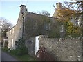
Great House, Welsh St Donats
Historic Houses plaque on the white gate
Image: © John Lord
Taken: 7 Nov 2008
0.05 miles
3
Welsh St. Donats parish church
The village church. What will become of such buildings in the coming years?
Image: © Jeremy Bolwell
Taken: 29 Jul 2011
0.07 miles
4
Stile and Church
A stile-ish approach to the parish church at St.Donats.
Image: © Alan Hughes
Taken: 13 Jan 2017
0.07 miles
5
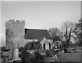
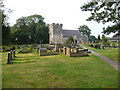
Welsh St Donats Parish Church and churchyard in the 1970s
The Parish Church, which is also known as the Church of St Donat, is seen here in a photograph from c. 1975. The church is a grade I listed building, and was listed in January 1963. An internet source (East Vale Group at http://www.eastvalechurches.org.uk/ChurchWelshStDonats.html ) describes the church’s ‘arched brace truss roof timbers (circa 1500) and 13th century font’ as having contributed to its grade I listing. According to the Welsh St Donats Community Website (at http://www.welsh-st-donats-community.btck.co.uk/ ), the church ‘has been a place of worship for over 800 years’.
Image: © eswales
Taken: Unknown
0.08 miles
6
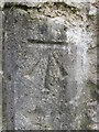
Ordnance Survey Cut Mark
This OS cut mark can be found on the SW face of St Donat's Church. It marks a point 117.720m above mean sea level.
Image: © Adrian Dust
Taken: 9 Apr 2016
0.08 miles
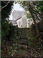
7

A glimpse through foliage
A church tower, old stone stile, damp foliage - St Donat’s Church, Welsh St Donats.
Image: © Alan Hughes
Taken: 30 Jun 2020
0.08 miles
8
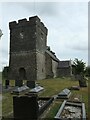
St Donats Church, Welsh St Donats
A Grade I listed building first mentioned in 1173 but the current church is mainly from the 14th century with some rebuilding in the following century and the inevitable Victorian restoration as well. Contains fine medieval roofs inside.
Image: © Colin Cheesman
Taken: 28 Jul 2022
0.08 miles
9
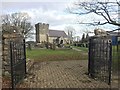
Parish Church at Welsh St.Donats
The parish church at Welsh St.Donats.
Image: © Alan Hughes
Taken: 13 Jan 2017
0.08 miles
10

Steps and stile to churchyard, Welsh St Donats
Image: © John Lord
Taken: 7 Nov 2008
0.08 miles