IMAGES TAKEN NEAR TO
Llanmihangel, COWBRIDGE, CF71 7LQ
Introduction
This page details the photographs taken nearby to CF71 7LQ by members of the Geograph project.
The Geograph project started in 2005 with the aim of publishing, organising and preserving representative images for every square kilometre of Great Britain, Ireland and the Isle of Man.

There are currently over 7.5m images from over14,400 individuals and you can help contribute to the project by visiting https://www.geograph.org.uk
Image Map
Images are licensed for reuse under creativecommons.org/licenses/by-sa/2.0
Notes
- Clicking on the map will re-center to the selected point.
- The higher the marker number, the further away the image location is from the centre of the postcode.
Image Listing (31 Images Found)
Images are licensed for reuse under creativecommons.org/licenses/by-sa/2.0
Image
Details
Distance
1
Ordnance Survey Cut Mark
This OS cut mark can be found on the wall west side of the road. It marks a point 73.119m above mean sea level.
Image: © Adrian Dust
Taken: 19 Apr 2018
0.03 miles
2
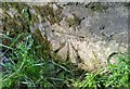
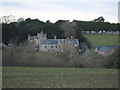
Llanmihangel Place
Plaster Llanmihangel, a Grade 1 listed Welsh Manor House.
Image: © Alan Hughes
Taken: 31 Oct 2016
0.12 miles
3
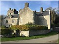
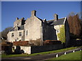
Plas Llanmihangel
This attractive property offered bed and breakfast, and there are many accounts by guests of the wonderful time they had there, but sadly in 2017 the owners retired from running this business.
Image: © HelenK
Taken: 22 Feb 2008
0.12 miles
5
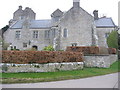
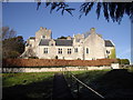
Plas Llanmihangel
Plas Llanmihangel has been described by The Royal Commission on Ancient Monuments as "one of the finest and most complete gentry houses in Glamorgan".
The house was first recorded in 1166 as a Grange occupied by a Norman Knight named John Norreys
Image: © M Hunter
Taken: 30 Nov 2008
0.12 miles
6
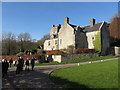
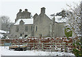
Llanmihangel Place, Llanmihangel
Built in the mid C16th, with additions in the late C16th and early C17th. In the care of Cadw.
Image: © John Lord
Taken: 19 Jan 2011
0.12 miles
8
Plas Llanmihangel, Vale of Glamorgan
Formerly a Tudor manor house, it has been extensively restored in recent years and now offers accommodation for visitors to the area.
Image: © Mick Lobb
Taken: 5 Feb 2009
0.13 miles
9
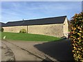
The Great Barn
Llanmihangel - the Great Barn.
Image: © Alan Hughes
Taken: 31 Oct 2016
0.13 miles
10
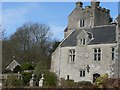
Plas Llanmihangel, near Cowbridge
Castellated central tower and front of building. Recorded as being a 'grange' in 1166 at that time in the ownership of a Norman knight John Norreys. The structure of the medieval house still stands but has been partly enclosed by early 16th century additions. After the 16th century little was done to alter the exterior of the house and it was only in the 1780's that some work was carried out to upgrade the most important bedroom. In the 1880's further work was carried out to bring the house up to the standards of the late 19th century. The building and surrounds have been lovingly restored and 'modernised' by the present owners since the mid to late 1980's to offer accommodation to visiting guests.
Image: © Mick Lobb
Taken: 19 Mar 2008
0.13 miles