IMAGES TAKEN NEAR TO
Clare Drive, COWBRIDGE, CF71 7HS
Introduction
This page details the photographs taken nearby to Clare Drive, CF71 7HS by members of the Geograph project.
The Geograph project started in 2005 with the aim of publishing, organising and preserving representative images for every square kilometre of Great Britain, Ireland and the Isle of Man.

There are currently over 7.5m images from over14,400 individuals and you can help contribute to the project by visiting https://www.geograph.org.uk
Image Map (Loading...)


Getting Data...Please wait
Leaflet Map data © OpenStreetMap
Images are licensed for reuse under creativecommons.org/licenses/by-sa/2.0
Notes
- Clicking on the map will re-center to the selected point.
- The higher the marker number, the further away the image location is from the centre of the postcode.
Image Listing (28 Images Found)
Images are licensed for reuse under creativecommons.org/licenses/by-sa/2.0
Image
Details
Distance
1

A waste of paint - Cowbridge
So the road was so narrow that they wanted to keep vehicles on the safe side of the road!
Image: © Mick Lobb
Taken: 11 Dec 2009
0.06 miles
2
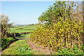
Invaders near Cowbridge
In what might be considered an idyllic landscape rapidly growing invaders of the hedgerows have sprung into life.
I believe this to be Himalayan Balsam (Impatiens glandulifera), an introduced horticultural specimen, related to the Busy Lizzie, that came to Britain in 1839 and has since escaped to become a major nuisance in the wild.
It is the tallest annual in the UK growing up to 3 metres tall in a season before dying back in autumn. An attractive plant with a distinctive purple pink flower that belies its destructive nature. Its flower has led to its slang name of 'Policeman's Helmet'- not that I have seen any poicemen wearing pink helmets as yet!
Each plant can produce up to 800 seeds and these are explosively released when their pods are mature. The 'explosion' can project the seeds up to 7 metres from the parent plant. This highly effective dispersal method enables the plant to rapidly colonise the damp and riparian habitats that it usually favours. The seeds may be further spread by water, explaining its favoured environment, and can remain viable for 2 years
Image: © Mick Lobb
Taken: 20 Apr 2009
0.10 miles
3
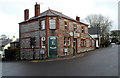
Trio Brasserie, Cowbridge
Located in eastern Cowbridge at the crossroads of Cardiff Road, Aberthin Road, Eastgate and St Athan Road. The Shorter Oxford English Dictionary defines brasserie as
"A (French) saloon selling beer and usually food; generally, an informal restaurant."
The second definition applies here.
Image: © Jaggery
Taken: 19 Jan 2012
0.14 miles
4
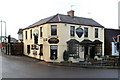
Edmondes Arms, Jack's Corner, Cowbridge
Pub on the corner of Cardiff Road and Aberthin Road. Both roads are the A4222 which makes a 90 degree turn here.
The name Jack’s Corner on the building recalls a dog that once lived here. The year on the pub name sign is 1899, but there is a reference to The Edmondes Arms Public House in an 1895 edition of a Kelly's Directory, so presumably the current building was built on the site of its predecessor. The Directory records that a Mrs Edmondes of High Street is a "principal landowner" in Cowbridge.
Image: © Jaggery
Taken: 19 Jan 2012
0.14 miles
5
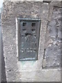
Ordnance Survey Flush Bracket (S1255)
This OS Flush Bracket can be found on the south face of the school. It marks a point 39.867m above mean sea level.
Image: © Adrian Dust
Taken: 9 Apr 2016
0.16 miles
6
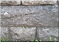
Bench Mark, Cowbridge
This bench mark is in the bus shelter against the remaining bridge parapet of the long closed Cowbridge and Aberthaw railway.
It is shown on the 1909 OS map but appears to be from George V or VI's era. Perhaps it is a replacement for an earlier one. The recorded elevation on the map is 101.3ft
Image: © Guy Butler-Madden
Taken: 23 Feb 2012
0.17 miles
7
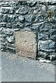
Ordnance Survey Cut Mark
This OS cut mark can be found on the north parapet of the old railway bridge on Cardiff Road. It marks a point 41.087m above mean sea level.
Image: © Adrian Dust
Taken: 19 Apr 2018
0.17 miles
8
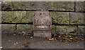
Old Milestone by the A4222, Eastgate, Cowbridge
Stone post by the A4222, in parish of Cowbridge with Llanblethian (Vale of Glamorgan District), Eastgate, Cowbridge, at junction with Aberthin Road, set in angled wall.
Inscription indistinct.
Surveyed
Milestone Society National ID: GLA_CFBE12
Image: © Milestone Society
Taken: Unknown
0.18 miles
9
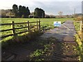
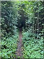
Track to Sewage Works
Track leading to sewage works near Llanblethian.
Image: © Alan Hughes
Taken: 16 Dec 2016
0.18 miles