IMAGES TAKEN NEAR TO
Channel View, PENARTH, CF64 5DQ
Introduction
This page details the photographs taken nearby to Channel View, CF64 5DQ by members of the Geograph project.
The Geograph project started in 2005 with the aim of publishing, organising and preserving representative images for every square kilometre of Great Britain, Ireland and the Isle of Man.

There are currently over 7.5m images from over14,400 individuals and you can help contribute to the project by visiting https://www.geograph.org.uk
Image Map
Images are licensed for reuse under creativecommons.org/licenses/by-sa/2.0
Notes
- Clicking on the map will re-center to the selected point.
- The higher the marker number, the further away the image location is from the centre of the postcode.
Image Listing (50 Images Found)
Images are licensed for reuse under creativecommons.org/licenses/by-sa/2.0
Image
Details
Distance
1
Clifftop Penarth
Houses on Plymouth Road overlooking the recreational lawns and the sea - by the Cliff Walk between Lavernock and Penarth.
Image: © Colin Smith
Taken: 7 Jun 2008
0.03 miles
2
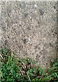
Ordnance Survey Rivet
This OS rivet can be found on the concrete base of the seat on Cliff Walk. It marks a point 23.262m above mean sea level.
Image: © Adrian Dust
Taken: 25 Sep 2017
0.07 miles
3

Wales Coast Path
Looking to the south from Penarth.
With the Islands of Flat holm and Steep holm in the Bristol Channel.
Image: © Robin Drayton
Taken: 13 Nov 2017
0.07 miles
4
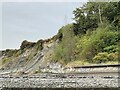
Cliff face, Penarth
The sea wall has clearly been successful in reducing tidal erosion. Note how vegetation has taken hold above the wall whereas to the left the cliff has continued to suffer from erosion.
Image: © Alan Hughes
Taken: 8 Sep 2022
0.07 miles
5
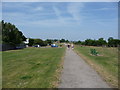
Part of the Wales Coast Path in Penarth
Busy with walkers, families, dog-walkers, sunbathers / sun worshippers and even two 'ladies who lunch' who have a patio table complete with sunshade in the shade of a tree over to the left and have been dining alfresco. Some people really know how to live.
Image: © Jeremy Bolwell
Taken: 13 Jul 2013
0.08 miles
6
Forrest Road, Penarth
The view west from the edge of Cliff Walk.
Image: © Jaggery
Taken: 24 Nov 2010
0.09 miles
7
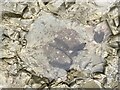
Dinosaur footprint
One of several dinosaur footprints discovered in late Triassic rocks on the Penarth foreshore in 2009 and confirmed in 2021. Thought to have been made by an early sauropod.
Image: © Alan Hughes
Taken: 8 Sep 2022
0.09 miles
8
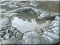
Dinosaur track
The pools of water help to show the line of the dinosaur tracks.
See also Image
Image: © Alan Hughes
Taken: 8 Sep 2022
0.09 miles
9
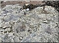
Dinosaur footprint
Footprint of a sauropod from c 210 million years ago.
Image: © Alan Hughes
Taken: 14 Sep 2022
0.09 miles
10
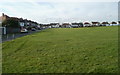
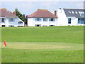
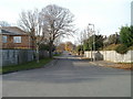
Houses at the edge of a miniature golf course, Penarth
The houses on the left are on Channel View; the longer row of houses is Plymouth Road, viewed across the southern edge of a miniature golf course. http://www.geograph.org.uk/photo/2192428
Image: © Jaggery
Taken: 24 Nov 2010
0.09 miles