IMAGES TAKEN NEAR TO
George Street, BARRY, CF63 4NL
Introduction
This page details the photographs taken nearby to George Street, CF63 4NL by members of the Geograph project.
The Geograph project started in 2005 with the aim of publishing, organising and preserving representative images for every square kilometre of Great Britain, Ireland and the Isle of Man.

There are currently over 7.5m images from over14,400 individuals and you can help contribute to the project by visiting https://www.geograph.org.uk
Image Map
Images are licensed for reuse under creativecommons.org/licenses/by-sa/2.0
Notes
- Clicking on the map will re-center to the selected point.
- The higher the marker number, the further away the image location is from the centre of the postcode.
Image Listing (184 Images Found)
Images are licensed for reuse under creativecommons.org/licenses/by-sa/2.0
Image
Details
Distance
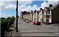
1
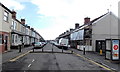
George Street Barry
Viewed from the Holton Road end looking SE towards a bend in the road opposite Digby Street.
Image: © Jaggery
Taken: 17 Mar 2013
0.02 miles
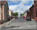
2
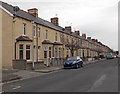
Castleland Street houses, Barry
Viewed from the corner of Cross Street http://www.geograph.org.uk/photo/3358935 looking towards Dock View Road.
Image: © Jaggery
Taken: 28 Feb 2013
0.03 miles
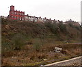
3
Southern end of Castleland Street, Barry
Castleland Street climbs away from Dock View Road, heading NNW towards Holton Road.
Image: © Jaggery
Taken: 28 Feb 2013
0.04 miles
4
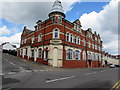
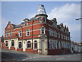
Sea View Labour Club, Barry
On the corner of Dock View Road and George Street, the club has views towards the Bristol Channel.
Image: © Jaggery
Taken: 26 Apr 2017
0.05 miles
5
Dock View Road houses, Barry
The row of houses extends from the corner of Lower Pyke Street to Sea View Labour Club http://www.geograph.org.uk/photo/5367112 on the corner of George Street. On the left, temporary fencing plugs a break in the railings above railway lines.
Image: © Jaggery
Taken: 26 Apr 2017
0.06 miles
6
Castleland Street, Barry
From Dock View Road, Castleland Street ascends towards Holton Road.
Image: © Jaggery
Taken: 26 Apr 2017
0.06 miles
7
Dock View Road buildings viewed from Barry Docks railway station
A view of Dock View Road between Castleland Street and George Street.
The large brick building, a former Seamen's Institute, http://www.geograph.org.uk/photo/1897179 is on the corner of Castleland Street.
Image: © Jaggery
Taken: 6 Jan 2013
0.06 miles
8
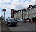
Warning sign - road narrows, Dock View Road, Barry
On the approach to this http://www.geograph.org.uk/photo/5373206 narrowing of Dock View Road.
The car parked alongside the sign is a 1.7 litre 1961 Ford.
Image: © Jaggery
Taken: 26 Apr 2017
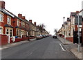
0.06 miles
10
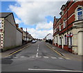
George Street, Barry
George Street ascends from Dock View Road towards Jewel Street, Digby Street and Holton Road.
Image: © Jaggery
Taken: 26 Apr 2017
0.07 miles