IMAGES TAKEN NEAR TO
Beatrice Road, BARRY, CF63 3QF
Introduction
This page details the photographs taken nearby to Beatrice Road, CF63 3QF by members of the Geograph project.
The Geograph project started in 2005 with the aim of publishing, organising and preserving representative images for every square kilometre of Great Britain, Ireland and the Isle of Man.

There are currently over 7.5m images from over14,400 individuals and you can help contribute to the project by visiting https://www.geograph.org.uk
Image Map
Images are licensed for reuse under creativecommons.org/licenses/by-sa/2.0
Notes
- Clicking on the map will re-center to the selected point.
- The higher the marker number, the further away the image location is from the centre of the postcode.
Image Listing (211 Images Found)
Images are licensed for reuse under creativecommons.org/licenses/by-sa/2.0
Image
Details
Distance
1
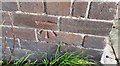
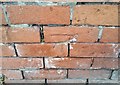
Ordnance Survey Cut Mark
This OS cut mark can be found on No14 Foster Street. It marks a point 14.441m above mean sea level.
Image: © Adrian Dust
Taken: 3 Feb 2018
0.04 miles
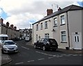
2
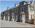
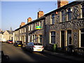
Courtenay Road, Barry
Houses on the east side of Courtenay Road, viewed from the Holton Road end.
The houses on the other side of the road stretch for more than twice the length of this side because several east side houses were demolished on the construction of Gladstone Road.
Image: © Jaggery
Taken: 16 Jun 2010
0.04 miles
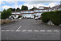
3
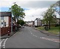
Up Holton Road, Barry
Holton Road ascends westwards towards the town centre.
The Hillary Rise junction and a Victorian pillarbox http://www.geograph.org.uk/photo/5366291 are on the left.
Image: © Jaggery
Taken: 26 Apr 2017
0.05 miles
4
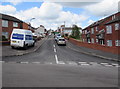
Up Hunt Place, Barry
Hunt Place ascends from Hillary Rise towards Holton Road.
Image: © Jaggery
Taken: 26 Apr 2017
0.05 miles
5
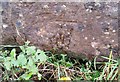
Ordnance Survey Cut Mark
This OS cut mark can be found on the wall north side of Holton Road. It marks a point 13.352m above mean sea level.
Image: © Adrian Dust
Taken: 3 Feb 2018
0.05 miles
6
Ordnance Survey Cut Mark
This OS cut mark can be found on the rock face south side of Gladstone Road. It marks a point 22.665m above mean sea level.
Image: © Adrian Dust
Taken: 3 Feb 2018
0.06 miles
7
Forster Street, Barry
Viewed from Holmes Street.
Image: © Jaggery
Taken: 26 Apr 2017
0.06 miles
8
Cotswold Rise, Barry
Houses set back from Quarella Street.
Image: © Jaggery
Taken: 26 Apr 2017
0.07 miles
10
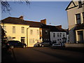
Corner of Charlotte Place and Rectory Rd, Barry
Image: © John Lord
Taken: 4 Mar 2011
0.07 miles