1
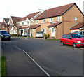
South side of Palmerston Primary School, Barry
Viewed from Pen-y-Bryn. The school, for children aged from 3-11, was founded in 1898, located in Cadoc Crescent. The school relocated here in March 1989.
The Palmerston area of Barry was not named after the 19th century British Prime Minister Lord Palmerston, but after the Palmer family, owners of much land hereabouts.
Image: © Jaggery
Taken: 2 Dec 2012
0.04 miles
2
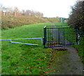
Entrance to Palmerston Primary School, Barry
The school, for children aged from 3-11, was founded in 1898, located in Cadoc Crescent.
The school relocated to this site on the north side of Pen-y-Bryn, Palmerston, in March 1989.
The Palmerston area of Barry was not named after the 19th century British Prime Minister Lord Palmerston, but after the Palmer family, owners of much land hereabouts.
Image: © Jaggery
Taken: 2 Dec 2012
0.06 miles
3
Turning area on the east side of Pen-y-Bryn, Palmerston, Barry
Located opposite Palmerston Primary School. http://www.geograph.org.uk/photo/3248192
Image: © Jaggery
Taken: 2 Dec 2012
0.08 miles
4
Pen-y-Bryn, Palmerston, Barry
Looking like a country road, Pen-y-Bryn connects Palmerston Primary School and the residential Greenacres http://www.geograph.org.uk/photo/3248162 ahead with Dobbins Road behind the camera.
Image: © Jaggery
Taken: 2 Dec 2012
0.09 miles
5
Children's play area, Pen-y-Bryn, Palmerston, Barry
Located below the south side of Pen-y-Bryn. http://www.geograph.org.uk/photo/3248186
Image: © Jaggery
Taken: 2 Dec 2012
0.09 miles
6
Greenacres houses, Palmerston, Barry
A view NW along the eastern arm of Greenacres, a road of about 140 modern houses at the eastern edge of Barry.
Image: © Jaggery
Taken: 2 Dec 2012
0.09 miles
7
Footpath to a children's playground, Pen-y-Bryn, Palmerston, Barry
The footpath, on the south side of Pen-y-Bryn, http://www.geograph.org.uk/photo/3248186 leads to a playground. http://www.geograph.org.uk/photo/3248219
Metal barriers prevent vehicles accessing the area ahead.
Image: © Jaggery
Taken: 2 Dec 2012
0.10 miles
8
Eastern arm of Greenacres, Palmerston, Barry
Modern houses in the east of Barry. The Vale of Glamorgan railway line is behind the houses ahead.
Image: © Jaggery
Taken: 2 Dec 2012
0.15 miles
9
Ordnance Survey Cut Mark
This OS cut mark can be found on the wall of No11 Dobbins Road. It marks a point 25.762m above mean sea level.
Image: © Adrian Dust
Taken: 3 Feb 2018
0.15 miles
10
Railway line, Palmerston, Barry
A view east from Palmerston Road bridge, along the Vale of Glamorgan railway line.
The next station ahead is Dinas Powys.
Image: © Jaggery
Taken: 2 Dec 2012
0.18 miles


