IMAGES TAKEN NEAR TO
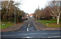
Laura Street, BARRY, CF63 2NU
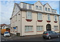
Introduction
This page details the photographs taken nearby to Laura Street, CF63 2NU by members of the Geograph project.
The Geograph project started in 2005 with the aim of publishing, organising and preserving representative images for every square kilometre of Great Britain, Ireland and the Isle of Man.

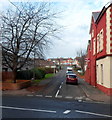
There are currently over 7.5m images from over14,400 individuals and you can help contribute to the project by visiting https://www.geograph.org.uk
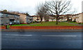
Image Map
Images are licensed for reuse under creativecommons.org/licenses/by-sa/2.0
Notes
- Clicking on the map will re-center to the selected point.
- The higher the marker number, the further away the image location is from the centre of the postcode.
Image Listing (73 Images Found)
Images are licensed for reuse under creativecommons.org/licenses/by-sa/2.0
Image
Details
Distance
1
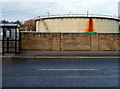
Gasholder on the north side of Cardiff Road, Barry
The c40 metre diameter gas holder is located inside a walled compound
between Laura Street and Verlon Close.
Image: © Jaggery
Taken: 2 Dec 2012
0.05 miles
2
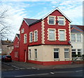
Conspicuous corner house, Cardiff Road, Barry
72 Cardiff Road, on the corner of Cadoc Crescent, is conspicuous both by its colours and by being significantly bigger than neighbouring houses. Perhaps it was formerly a corner shop or pub.
Image: © Jaggery
Taken: 2 Dec 2012
0.06 miles
3
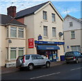
Misha News, Barry
Newsagents, off licence and a Mace Express store at 81 Cardiff Road, on the corner of Laura Street. There is a post box on the corner (here hidden by a car) which suggests that this may formerly have been a post office.
Image: © Jaggery
Taken: 2 Dec 2012
0.06 miles
4
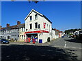
Joy's News and Off License
At the corner of Cardiff Road and Laura Street
Image: © Eirian Evans
Taken: 23 Jun 2021
0.06 miles
5
Eastern arm of Cadoc Crescent, Barry
Viewed across Cardiff Road (A4055). The western arm http://www.geograph.org.uk/photo/3248527 of the crescent is about 100 metres away.
Image: © Jaggery
Taken: 2 Dec 2012
0.07 miles
6
Lennox Green, Barry
Viewed across Cardiff Road (the A4055). Lennox Green is an area of 24 flats, arranged in groups of 8 along 3 sides of a rectangle. The western and eastern sides are adjacent to the western and eastern arms of Cadoc Crescent. The northern side (behind the trees) borders James Street.
Lennox Green was named after Dr Mary Lennox who was Barry's first female Medical Officer of Health.
Image: © Jaggery
Taken: 2 Dec 2012
0.07 miles
7
Grange Court, Barry
Grange Court contains 9 flats, located at 82 Cardiff Road on the corner of Laura Street.
Image: © Jaggery
Taken: 2 Dec 2012
0.07 miles
8
Western arm of Cadoc Crescent, Barry
A view north from Cardiff Road (the A4055). The first building on the left side of the road ahead is a former Victorian school, now Palmerston Community Learning Centre. http://www.geograph.org.uk/photo/3248480
The junction of the eastern arm of Cadoc Crescent and Cardiff Road is about 100 metres away. http://www.geograph.org.uk/photo/3248620
Image: © Jaggery
Taken: 2 Dec 2012
0.08 miles
9
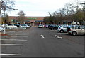
Waitrose, Barry
The Waitrose in Barry is set back 170 metres from the east side
of Palmerston Road, with a large car park in between.
Image: © Jaggery
Taken: 2 Dec 2012
0.08 miles
10
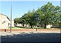
Lennox Green
Here there are 24 flats, surrounding a green rectangle.
Image: © Eirian Evans
Taken: 23 Jun 2021
0.08 miles