IMAGES TAKEN NEAR TO
Greenfield Road, BARRY, CF62 8UP
Introduction
This page details the photographs taken nearby to Greenfield Road, CF62 8UP by members of the Geograph project.
The Geograph project started in 2005 with the aim of publishing, organising and preserving representative images for every square kilometre of Great Britain, Ireland and the Isle of Man.

There are currently over 7.5m images from over14,400 individuals and you can help contribute to the project by visiting https://www.geograph.org.uk
Image Map (Loading...)


Getting Data...Please wait
Leaflet Map data © OpenStreetMap
Images are licensed for reuse under creativecommons.org/licenses/by-sa/2.0
Notes
- Clicking on the map will re-center to the selected point.
- The higher the marker number, the further away the image location is from the centre of the postcode.
Image Listing (34 Images Found)
Images are licensed for reuse under creativecommons.org/licenses/by-sa/2.0
Image
Details
Distance
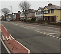
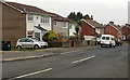
1
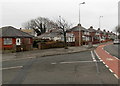
Corner of Colcot Road and Whitewell Road, Barry
The bungalows are at the SW end of Whitewell Road.
Image: © Jaggery
Taken: 6 Jan 2013
0.06 miles
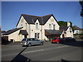
3
St David's Methodist Church, Barry
On the corner of Winston Road and Colcot Road. The first Methodist place of worship in the area was a Mission run at a war army camp in 1914. Later, a Sunday school was set up in a house to serve the Colcot area of Barry, followed by a building fondly referred to as a tin shack. The present church's foundation stone was laid on July 24th 1965.
Image: © Jaggery
Taken: 6 Jan 2013
0.07 miles
4
St David's Methodist Church, Colcot Rd, Barry
Image: © John Lord
Taken: 23 May 2010
0.07 miles
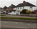
5
Houses at the northern end of Colcot Road, Barry
The houses behind the more distant tree are opposite the Colcot Arms. http://www.geograph.org.uk/photo/3286004
Image: © Jaggery
Taken: 6 Jan 2013
0.07 miles
6
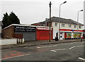
Two Winston Road shops, Colcot, Barry
Jennies Creations, barber shop and hair & beauty salon is next door to G9 Fish Bar (Chinese meals
to take away). A One Stop convenience store is on the right. http://www.geograph.org.uk/photo/3286172
Image: © Jaggery
Taken: 6 Jan 2013
0.08 miles
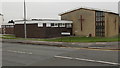
7
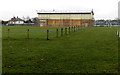
Barry Sports Centre
A view from Port Road West of an edge of the Highfield Road sports centre.
Image: © Jaggery
Taken: 6 Jan 2013
0.09 miles
8
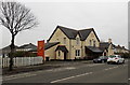
Colcot Arms, Barry
A member of the Sizzling Pubs chain, the pub is on the east side of Colcot Road in the north of Barry.
Image: © Jaggery
Taken: 6 Jan 2013
0.09 miles
9
SW end of Whitewell Road, Barry
Viewed from the Colcot Road end. Whitewell Road is in the Merthyr Dyfan area in the north of Barry.
Image: © Jaggery
Taken: 6 Jan 2013
0.09 miles
10
Dyffryn Place, Barry
Houses at the NE end of Dyffryn Place viewed across Colcot Road.
Dyffryn Place is a cul-de-sac. Houses at SW end are adjacent to the grounds of Barry Hospital.
Image: © Jaggery
Taken: 6 Jan 2013
0.09 miles