IMAGES TAKEN NEAR TO
Park Avenue, BARRY, CF62 7RL
Introduction
This page details the photographs taken nearby to Park Avenue, CF62 7RL by members of the Geograph project.
The Geograph project started in 2005 with the aim of publishing, organising and preserving representative images for every square kilometre of Great Britain, Ireland and the Isle of Man.

There are currently over 7.5m images from over14,400 individuals and you can help contribute to the project by visiting https://www.geograph.org.uk
Image Map (Loading...)


Getting Data...Please wait
Leaflet Map data © OpenStreetMap
Images are licensed for reuse under creativecommons.org/licenses/by-sa/2.0
Notes
- Clicking on the map will re-center to the selected point.
- The higher the marker number, the further away the image location is from the centre of the postcode.
Image Listing (230 Images Found)
Images are licensed for reuse under creativecommons.org/licenses/by-sa/2.0
Image
Details
Distance
1
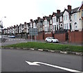
Long row of houses, Park Avenue, Barry
Viewed from the southwest end of Broad Street.
Image: © Jaggery
Taken: 11 Sep 2019
0.01 miles
2
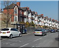
Park Avenue houses, Barry
Viewed from the St Nicholas Road end. There are houses on only one side of the road here.
On the other side is a railway cutting.
Image: © Jaggery
Taken: 5 Mar 2013
0.01 miles
3
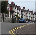
Park Avenue houses, Barry
Set about 2 metres above road level, the houses are opposite
railings and bushes above railway lines in a cutting near Barry station.
Image: © Jaggery
Taken: 11 Sep 2019
0.01 miles
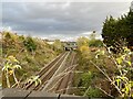
4
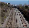
Vale of Glamorgan Line railway, Barry
Viewed from the St Nicholas Road bridge looking towards the A4055 bridge, behind which is Barry railway station.
Image: © Jaggery
Taken: 5 Mar 2013
0.03 miles
5
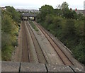
Vale of Glamorgan railway line between two road bridges, Barry
Viewed from St Nicholas Road bridge looking towards
Harbour Road bridge, northeast of which is Barry railway station.
Image: © Jaggery
Taken: 11 Sep 2019
0.03 miles
6
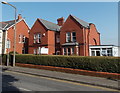
Abbeyfield, Barry
Ty Dan Evans, 43 St. Nicholas Road, Barry is owned by Abbeyfield Wales Society Ltd which provides housing with support for older people. Residents here live their lives as independently as they wish,
with the safety net of a caring environment.
Image: © Jaggery
Taken: 5 Mar 2013
0.03 miles
8
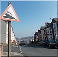
20% descent ahead on Miskin Street, Barry
The sign on the corner of Clifton Street shows a 20% (1 in 5) descent ahead towards the A4055.
Image: © Jaggery
Taken: 5 Mar 2013
0.03 miles
9
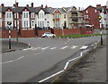
Zebra crossing, Harbour Road, Barry
Seven-stripe crossing at the northern end of Harbour Road.
Image: © Jaggery
Taken: 11 Sep 2019
0.04 miles
10
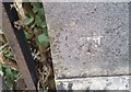
Ordnance Survey Cut Mark
This OS cut mark can be found on the NE parapet of the railway bridge. It marks a point 23.906m above mean sea level.
Image: © Adrian Dust
Taken: 28 Feb 2018
0.04 miles