IMAGES TAKEN NEAR TO
Bryn Y Gloyn, BARRY, CF62 3LD
Introduction
This page details the photographs taken nearby to Bryn Y Gloyn, CF62 3LD by members of the Geograph project.
The Geograph project started in 2005 with the aim of publishing, organising and preserving representative images for every square kilometre of Great Britain, Ireland and the Isle of Man.

There are currently over 7.5m images from over14,400 individuals and you can help contribute to the project by visiting https://www.geograph.org.uk
Image Map (Loading...)


Getting Data...Please wait
Leaflet Map data © OpenStreetMap
Images are licensed for reuse under creativecommons.org/licenses/by-sa/2.0
Notes
- Clicking on the map will re-center to the selected point.
- The higher the marker number, the further away the image location is from the centre of the postcode.
Image Listing (50 Images Found)
Images are licensed for reuse under creativecommons.org/licenses/by-sa/2.0
Image
Details
Distance
1
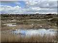
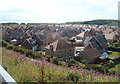
Rhoose Point housing estate
Old gravel pits and new housing at Rhoose Point.
Image: © Alan Hughes
Taken: 12 Apr 2021
0.00 miles
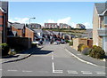
2
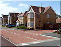
Corner of Bryn y Gloyn and Llety'r Eos, Rhoose
Part of a recent development of several hundred houses located near Rhoose Point.
Image: © Jaggery
Taken: 11 Jun 2011
0.02 miles
3
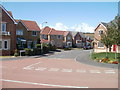
Cilgant-y-Meillion houses, Rhoose
Viewed from Bryn y Gloyn, part of a recent development of several hundred houses located near Rhoose Point.
Image: © Jaggery
Taken: 11 Jun 2011
0.03 miles
4
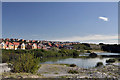
Flooded quarry workings and housing estate - Rhoose Point
Image: © Mick Lobb
Taken: 9 Sep 2009
0.03 miles
5
Houses, houses everywhere, Rhoose
A view from Bryn y Gloyn of part of a recent development of several hundred houses located near Rhoose Point.
Image: © Jaggery
Taken: 11 Jun 2011
0.07 miles
6
Rhoose Point
Layers of sedimentary rocks in the cliff face near Rhoose Point.
Image: © Alan Hughes
Taken: 6 Jun 2016
0.09 miles
7
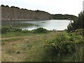
Lake and cliff near Rhoose Point
There was formerly a cement works and quarry in this area. Blue Lias limestone and clay from the quarry was used in the works.
Image: © Jaggery
Taken: 11 Jun 2011
0.09 miles
8
Heol Pilipala, Rhoose
Viewed from Bryn y Gloyn. Heol Pilipala is at the western edge
of a recent development of several hundred houses located near Rhoose Point.
The distant houses on higher ground are in Trem Echni.
Image: © Jaggery
Taken: 11 Jun 2011
0.10 miles
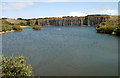
9
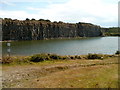
Cliff and lake near Rhoose Point
Viewed from Bryn y Gloyn. Rhoose Point on the Bristol Channel coast is on the far side of the cliff.
Image: © Jaggery
Taken: 11 Jun 2011
0.10 miles
10
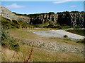
Cliffs and the eastern edge of a lake near Rhoose Point
Viewed from Bryn y Gloyn. The Bristol Channel coast is on the far side of the cliffs.
Image: © Jaggery
Taken: 11 Jun 2011
0.10 miles