IMAGES TAKEN NEAR TO
Marcross, LLANTWIT MAJOR, CF61 1ZH
Introduction
This page details the photographs taken nearby to CF61 1ZH by members of the Geograph project.
The Geograph project started in 2005 with the aim of publishing, organising and preserving representative images for every square kilometre of Great Britain, Ireland and the Isle of Man.

There are currently over 7.5m images from over14,400 individuals and you can help contribute to the project by visiting https://www.geograph.org.uk
Image Map
Images are licensed for reuse under creativecommons.org/licenses/by-sa/2.0
Notes
- Clicking on the map will re-center to the selected point.
- The higher the marker number, the further away the image location is from the centre of the postcode.
Image Listing (68 Images Found)
Images are licensed for reuse under creativecommons.org/licenses/by-sa/2.0
Image
Details
Distance
1
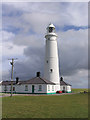
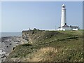
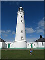
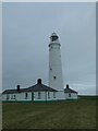
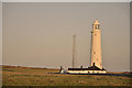
Nash Point Lighthouse
Nash Point Lighthouse (Wikipedia) https://en.wikipedia.org/wiki/Nash_Point
The Nash Point Lighthouse is a Grade II listed building, dating from 1831–32. There are two lights, a high light and a low light, located at a distance of around 300 metres from one another. The leading light was removed during the 1920s because of the shifting location of the Nash sandbank. The lighthouse was designed by James Walker, the chief engineer for Trinity House. Its construction is said to have been spurred by the wreck of The Frolic on the Nash Sands in March 1831, which resulted in over 50 deaths, including that of Lt-Col N McLeod. The ship was on its way from Bristol to Haverfordwest. First lit in 1832, the lighthouse was electrified in 1968. Nash Point Lighthouse became the last manned lighthouse in Wales, and was automated in 1998. The lighthouse is now open to visitors, and is often used as a wedding venue; Trinity House provides public tours. The fog signal, no longer needed by ships, is sounded on the first Saturday and third Sunday of each month as an additional attraction to visitors. Currently, cottages around the lighthouse can be rented out as holiday accommodation.
Image: © Philip Cornwall
Taken: 2 Dec 2012
0.01 miles
2
Eastern lighthouse at Nash Point
Completed in 1832 following the tragic loss of 80 lives when the packet steamer Frolic had been shipwrecked in the previous year.
Image: © Alan Hughes
Taken: 5 Sep 2023
0.01 miles
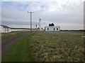
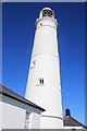
4
Upper (East) Lighthouse and cottages, Nash Point, St Donats
This is the upper of the two lighthouses built by Thomas Prothero in 1830 to assist navigation of the Bristol Channel.
The eastern lighthouse represents the original high light, and continued in use after the closure of the low light in c. 1924. Its lantern was replaced in 1867, the lens was replaced in 1924. It was electrified in 1971.
The lighthouse is listed as Grade II by Cadw.
Image: © Colin Cheesman
Taken: 1 Feb 2022
0.01 miles
5
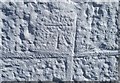
Ordnance Survey Cut Mark
This OS cut mark can be found on the SW face of the lighthouse. It marks a point 32.074m above mean sea level.
Image: © Adrian Dust
Taken: 19 Apr 2018
0.01 miles
7
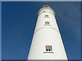
Worm's eye view of the lighthouse, Nash Point
Image: © Mick Lobb
Taken: 11 Feb 2009
0.01 miles
8
Nash Point Lighthouse at the going down of the sun
Image: © Mick Lobb
Taken: 12 Sep 2009
0.01 miles