IMAGES TAKEN NEAR TO
Byron Court, LLANTWIT MAJOR, CF61 1AW
Introduction
This page details the photographs taken nearby to Byron Court, CF61 1AW by members of the Geograph project.
The Geograph project started in 2005 with the aim of publishing, organising and preserving representative images for every square kilometre of Great Britain, Ireland and the Isle of Man.

There are currently over 7.5m images from over14,400 individuals and you can help contribute to the project by visiting https://www.geograph.org.uk
Image Map
Images are licensed for reuse under creativecommons.org/licenses/by-sa/2.0
Notes
- Clicking on the map will re-center to the selected point.
- The higher the marker number, the further away the image location is from the centre of the postcode.
Image Listing (25 Images Found)
Images are licensed for reuse under creativecommons.org/licenses/by-sa/2.0
Image
Details
Distance
3
Shakespeare Drive, Llantwit Major
The roads in this small development are all named after great figures in literature.
Image: © Mick Lobb
Taken: 3 Feb 2009
0.11 miles
4
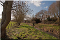
Field beside the Hoddnant - Boverton
Part of the settlement of Trebeferad can be seen on the skyline to the right.This was established under the Land Settlement Scheme of 1936 and described as a '600 acre jewel in the crown of the Welsh Land Settlement Association'. It provided employment and a healthier outlook for between 60-70 unemployed miners and their families during the years of the depression of the 1930's. Pigs, sheep and poultry were kept by those working here and there was a thriving market gardening enterprise. Crops cultivated included spring cabbage, peas, carrots, brussels sprouts and fruit such as strawberries. Three acres of glasshouses were also provided for the production of tomatoes. Produce was primarily sold locally but also as far afield as the west-country. Sixty houses were provided for families and planned in a garden village style, the architect being Alwyn Lloyd who based it on plans adopted by the Welsh Garden Cities Association who campaigned for better housing for the people of Wales.
Image: © Mick Lobb
Taken: 26 Feb 2011
0.12 miles
5
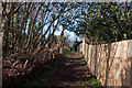
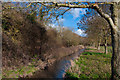
Footpath 'tween trees and fence - Boverton
Image: © Mick Lobb
Taken: 26 Feb 2011
0.13 miles
6
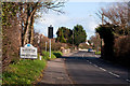
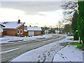
Entering Boverton from the west
Development of the nearby airfield, now in the penultimate stages of its long and useful life as a military base, promoted expansion of the village and nearby Llantwit Major to the extent that their borders seem no longer to exist. Such is the case now when more and more people seek land to live on with the result that there will no longer be enough available to meet their basic need for agricultural use. To the right of the village sign a speed warning device that has replaced the speed trap camera that was a short lived attempt to slow traffic - prosaically beside the local cemetery.
Image: © Mick Lobb
Taken: 26 Feb 2011
0.14 miles
7
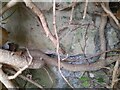
Ordnance Survey Cut Mark
This OS cut mark can be found on the wall north side of the road. It marks a point 33.107m above mean sea level.
Image: © Adrian Dust
Taken: 6 Sep 2022
0.15 miles
8
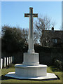
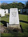
Memorial Cross - Llantwit Major
Located in a corner of the town cemetery the cross commemorates the lives of the RAF servicemen of several nations who are buried here. Some of those resting here died during peace time.
Image: © Mick Lobb
Taken: 8 Mar 2010
0.15 miles
9
Grave of Flying Officer Josef Nejezchleba (Royal Air Force) - Llantwit Major
Though the headstone relates to Royal Air Force service, the emblem on the headstone indicates that this casualty of war was Czechoslovakian. One of many who were able to flee their homelands to fight a common enemy only to have their last resting place in this foreign field. Others of his nationality lie nearby. Perhaps they were victims of the same incident but who now will tell their story?
Image: © Mick Lobb
Taken: 8 Mar 2010
0.15 miles
10
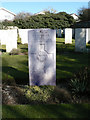
The grave of Sgt. R C Turner (Royal New Zealand Air Force) - Llantwit Major
Image: © Mick Lobb
Taken: 8 Mar 2010
0.15 miles