IMAGES TAKEN NEAR TO
Rhydlafar Drive, CF5 6HU
Introduction
This page details the photographs taken nearby to Rhydlafar Drive, CF5 6HU by members of the Geograph project.
The Geograph project started in 2005 with the aim of publishing, organising and preserving representative images for every square kilometre of Great Britain, Ireland and the Isle of Man.

There are currently over 7.5m images from over14,400 individuals and you can help contribute to the project by visiting https://www.geograph.org.uk
Image Map
Images are licensed for reuse under creativecommons.org/licenses/by-sa/2.0
Notes
- Clicking on the map will re-center to the selected point.
- The higher the marker number, the further away the image location is from the centre of the postcode.
Image Listing (8 Images Found)
Images are licensed for reuse under creativecommons.org/licenses/by-sa/2.0
Image
Details
Distance
1
Minor Road
Minor road leading to St.Fagans.
Image: © Alan Hughes
Taken: 31 May 2017
0.11 miles
2
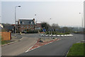
Rhydlafar Drive, Rhydlafar.
This modern housing development is built on the site of The Prince Of Wales Hospital at Rhydlafar near Cardiff.
Image: © Peter Wasp
Taken: 28 Mar 2007
0.12 miles
3
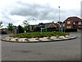
Roundabout and Housing
Roundabout and housing estate near Rhydlafr.
Image: © Alan Hughes
Taken: 31 May 2017
0.12 miles
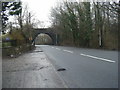
4
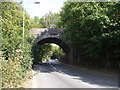
Bridge of dismantled railway over the A4119
Image: © John Lord
Taken: 1 Oct 2009
0.19 miles
5
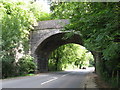
Former railway bridge on A4119
The bridge once carried the line from Barry towards Walnut Tree Viaduct / Caerphilly.
Image: © Gareth James
Taken: 25 Sep 2010
0.20 miles
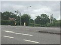
6
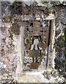
Ordnance Survey Flush Bracket (S9120)
This OS Flush Bracket can be found on the north buttress of the Railway Bridge. It marks a point 48.767m above mean sea level.
Image: © Adrian Dust
Taken: 28 Oct 2019
0.20 miles
7
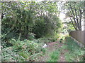
Route of dismantled railway near Radyr
Image: © Gareth James
Taken: 25 Sep 2010
0.20 miles