IMAGES TAKEN NEAR TO
Croft Y Genau, CARDIFF, CF5 6DS
Introduction
This page details the photographs taken nearby to Croft Y Genau, CF5 6DS by members of the Geograph project.
The Geograph project started in 2005 with the aim of publishing, organising and preserving representative images for every square kilometre of Great Britain, Ireland and the Isle of Man.

There are currently over 7.5m images from over14,400 individuals and you can help contribute to the project by visiting https://www.geograph.org.uk
Image Map
Images are licensed for reuse under creativecommons.org/licenses/by-sa/2.0
Notes
- Clicking on the map will re-center to the selected point.
- The higher the marker number, the further away the image location is from the centre of the postcode.
Image Listing (6 Images Found)
Images are licensed for reuse under creativecommons.org/licenses/by-sa/2.0
Image
Details
Distance
1
Road bridge over Taff Vale Railway
Crofft-Y-Genau Road over Taff Vale trackbed
Image: © Ray Durrant
Taken: 31 Aug 2011
0.06 miles
2
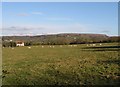
Croft y Genau, Rhydlafar
Ardal wledig i'r gogledd o Sain Ffagan ger Fferm Crofft y Genau gyda golygfeydd o fynydd y Garth.
A rural area north of St Fagans near Croft y Genau Farm with views of the Garth Mountain.
Image: © Penri Williams
Taken: 21 Feb 2005
0.07 miles
4
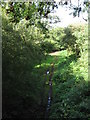
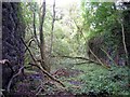
Route of dismantled railway west of Cardiff
Image: © Gareth James
Taken: 25 Sep 2010
0.08 miles
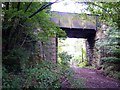
5
Rail over Rail
Barry Railway over Taff Vale Railway,bridge gone but supporting walls remain
Image: © Ray Durrant
Taken: 31 Aug 2011
0.13 miles
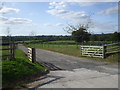
6
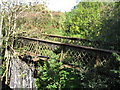
Utilities bridge crossing route of former railway, near Cardiff
Image: © Gareth James
Taken: 25 Sep 2010
0.22 miles